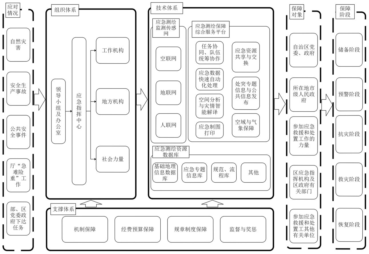
3.1 组织体系
按照统一领导、分级负责[8]、部门协同、联动响应、依靠群众的原则建立自然资源应急测绘保障组织体系和机构[7]。
(1)领导小组及办公室。负责应急测绘保障日常管理工作,负责与“应急处突”部门保持密切联系,了解需求;负责组织开展演练;负责预案编制和修订;编制年度经费预算;负责有关监督管理工作。
(2)应急测绘保障指挥中心。负责根据领导小组及办公室要求,下达应急测绘保障指令,负责指挥、调度、协调厅应急测绘保障工作机构成员单位。
(3)工作机构。厅各直属事业单位为应急测绘保障主要工作机构,对一级、二级、三级预案进行响应,承担由领导小组办公室和指挥中心下达和部署的应急测绘保障具体工作。
(4)地方机构。设区市、县(市、区)自然资源主管部门是地方机构,坚持属地管理原则[14],负责响应一级预案,按照领导小组办公室和指挥中心指令配合完成超出属地应对能力的应急测绘保障工作。
(5)社会力量。依靠群众力量,将各地具有优势资源、技术的相关企、事业单位或者个人等社会力量纳入自治区应急测绘保障体系,必要时执行一级响应,按指挥中心按照统一领导、专常结合原则,统筹领导、组织协调社会力量参与应急测绘保障工作。
(6)各级主体之间的应急联动的机制和关键技术。在制度层面,各级主体之间应急联动机制通过本级应急预案“纵向互联,横向互通”。领导小组及办公室统一指导制定本级预案,预案中明确本级组织结构及分工,做到指令、信息、数据的承上启下,畅通流转,确保多层级、多主体应急联动工作的顺利开展。
在技术层面,应急测绘保障指挥中心通过“广西应急测绘保障综合服务平台”指挥调度各级主体协同开展应急联动工作(详见本文“技术体系”)。
3.2 技术体系
以“数据获取准实时化、数据处理自动化、分析解译智能化、信息服务网络化”为目标建设技术体系,重点建设“广西应急测绘监测传感网、广西应急测绘资源数据库、广西应急测绘保障服务平台”[15]。
(1)广西应急测绘监测传感网。“天—空—地—人—网”一体化观测网络是对地观测领域的科学前沿,也是应急测绘中灾情信息获取的最主要手段[16]。广西应急测绘监测传感网依托国家应急测绘保障南宁基地建设成果、自然资源“天—空—地—人—网”多维立体协同感知网进行建设[9]。重点建设“空联网”、“地联网”、“人联网”三个部分[9],利用“空—地—人”网一体化灾害现场信息的协同获取[17],解决突发事件现场信息快速、全面、准实时、动态获取的问题。
空联网[9]。将国家应急测绘保障南宁基地的彩虹-4无人机、广西自然资源厅厅属各事业单位、各设区市自然资源主管部门以及社会力量和个人无人机设备、传感器设备连接组网[18-19],形成光学、高光谱、红外、LiDAR、SAR、倾斜摄影、视频等各种遥感数据快速获取能力。
地联网[9]。将国家应急测绘保障南宁基地的应急监测车、移动测量车,广西自然资源厅厅属各事业单位、广西各设区市自然资源主管部门以及社会力量和个人的各类监测、测量、调查等装备连接组网,形成突发事件前线现场勘测与现场数据的采集能力[20]。
人联网[9]。通过普适型、智能化终端设备或者安装普惠性APP,利用移动互联网(互联网)等网络技术,将参与自然资源调查监测的专业队伍、基层干部、社会公众联网,充分发挥各自的优势实现各类外业调查监测数据的第一时间采集。人联网的主要组成包括区市县各级专业队伍、基层干部和社会公众。
(2)广西应急测绘资源数据库。依托国家应急测绘保障南宁基地“国家应急测绘资源广西共享节点”进行建设[15]。对基础地理信息、基础应急专题信息等应急成果数据;应急测绘作业标准规范、预案、流程指导等文档类数据;应急测绘队伍、装备信息;事件信息库、预案库、知识库、模型库、案例库、文档库的综合数据库等知识类进行存储和管理。
(3)广西应急测绘保障综合服务平台。依托“广西无人机应急联动服务平台”[15]和广西“泛像控库及二三维影像自动化处理系统”进行建设。重点解决任务协同、队伍统筹协作;应急数据快速自动化处理;空间分析与智能灾情解译;应急制图打印;应急资源共享与交换;处突专题信息与公共信息发布;空域与气象保障等问题[21]。
任务协同、队伍统筹协作。依托“广西应急测绘联动服务平台”实时掌握各类、各级应急队伍、应急装备的的位置、工作状态。启动预案后,就近、快速统筹调动事发地应急测绘力量协同开展应急测绘任务。实现“数据获取准实时化”。获取的遥感数据通过网络传输进入“广西应急测绘资源数据库”,进入数据自动化处理的任务流程。
应急数据快速自动化处理。依托“泛像控库及二三维影像自动化处理系统”软硬件,对事发现场发回的多源航空遥感影像数据进行化数据进行集群化、多维度并行处理,生产影像、高程、地表模型和三维模型等地理信息数据。实现“数据处理自动化”。产出的成果数据用于空间分析、灾情解译、应急地图制图等工作。
空间分析与灾情智能解译。依托“广西壮族自治区自然资源监测动态感知大脑”,融合天、空、地多维数据,综合运用视觉AI和深度学习技术,基于多波段、多极化、主被动微波遥感的自然地理现象自动解译理论,通过自我训练迭代,可以实现微波遥感影像灾情信息自动快速解译[22]。进而开展空间分析工作和灾情自动解译工作。实现“分析解译智能化”。
应急制图打印。制定各类应急专题图的制图标准规范和模板,建设一套应急制图云系统,使本地和事发地的“应急处突”部门可以调用已有应急基础地理信息数据、自动化处理生产现势性的应急地理信息数据、分析解译后的专题数据等完成智能化制图,在连接本地绘图设备后,快速打印用于满足应急响应、应急指挥、应急救援、应急安置、重建规划等所需的各类图纸图件[23-25]。
应急资源共享与交换。依托“国家应急测绘资源广西共享节点”和“广西应急测绘数据快速传输网络”,通过应用云计算、大数据、物联网、人工智能、融合通信、5G等前沿技术手段[26],实现应急测绘数据的在突发事件现场、突发事件所在市县区、国家航空应急测绘保障南宁基地、应急测绘保障对象间的应急测绘数据快速传输和交换工作。有助于解决应急信息“获取难”“融合难”“共享难”“应用难”等问题[26]。
处突专题信息与公共信息发布。依托“广西无人机应急联动服务平台”,开发兼顾志愿者地理信息的应急测绘服务网站[27],以面向任务的应急测绘聚焦服务模式[28]为“应急处突”部门提供专题应急队伍分布、任务执行进度、过程监控、地理信息空间查询分析、导航定位、空域和气象保障服务、预警等专题性信息服务;为公众提供舆情上报、任务执行进度、地理信息空间查询分析、导航定位、气象保障、预警等一般性公共信息服务。实现“信息服务网络化”[29-31]。
空域与气象保障。依托“广西无人机应急联动服务平台”,开发应急测绘门户网站空域和气象保障模块,空域保障方面提供空域审批流程指导、空域批件查询、空域管制分区查询、获批空域范围查询、放飞申请流程查询等空域保障服务;气象保障方面提供未来30天中长期天气预报用于飞行任务规划、提供未来一周天气预报用于制定飞行计划、提供未来两小时天气预报用于飞行任务执行、提供飞行区域实时天气预警用于应急返航和终止飞行任务。实现“信息服务网络化”[29-31]。
(4)多平台、多网络的应急数据融合。为提高应急测绘数据的可用性、可靠性、实时性,应急测绘数据需要实现多平台、多网络的数据融合。在不同的硬件设备、软件系统、通信网络之间,实现应急测绘数据的无缝对接、快速传输、高效融合,提高应急测绘数据的可用性、可靠性、实时性。
多平台数据获取与传输。利用卫星、无人机、航空、地面等多种手段,实时采集灾区的地理、环境、灾情、救援等数据,形成海量、异构、动态的应急测绘数据源。建立应急测绘数据的传输链路和接口,实现应急测绘数据的实时同步、动态更新、增量传输,提高应急测绘数据的时效性和准确性。
应急数据融合后管理与集成。建立应急测绘数据的仓库或云平台,实现应急测绘数据的集中存储、统一管理、安全防护,提供数据共享、检索、交换等服务,满足各级各类应急测绘数据的需求。建立应急测绘数据的集成模式,实现应急测绘数据的空间集成、时间集成、语义集成、多维集成,提高应急测绘数据的完整性和可信性。
应急数据可视化与分析。利用大数据、人工智能、地理信息等技术,对应急测绘数据进行挖掘、分析、研判,提取有价值的信息,构建风险评估、预警预报、应急方案等模型和算法,为应急决策提供智能化、专业化、精细化的手段。利用三维数字地球、虚拟现实、增强现实等技术,对应急测绘数据进行多维度、多层次、多效果的可视化展示,实现应急测绘数据的直观表达、交互操作、动态演示,为应急指挥提供辅助支持。
依托“广西无人机应急测绘联动服务平台”,从技术角度实现各类应急装备、应急数据的融合。通过该平台能够把应急部门的各类应急设备连接起来,变成应急测绘资源,解决了应急装备及资源利用率不高和协同共享不足的问题。通过平台融合各类应急数据,并快速回传灾害点影像、音视频等应急数据,极大提升应急测绘的响应速度和能力。通过多平台、多网络的数据融合,也提高了应急数据共享和利用效率,实现数据增值、数据赋能。