1.2.1 现状地质灾害强度指数Zx
现状地质灾害强度指数Zx可以用灾害的点密度、面密度和体密度求得,如式(2):
Zx=a+b+c(2)
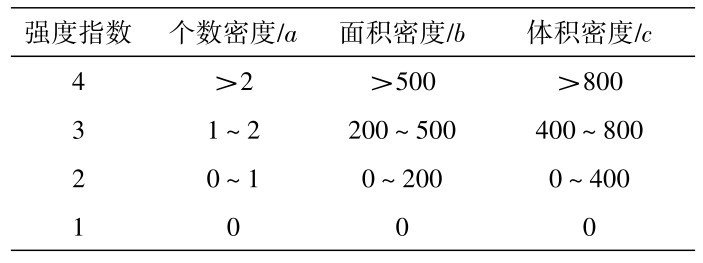
式(2)中:a为灾害点数量密度指数;b为灾害面积密度指数;c为灾害体积密度指数。各密度指数计算公式为:个数密度a=x/0.25;面积密度b=y/60;体积密度c=z/100,其中x为各评价单元灾害点个数,y为各评价单元灾害点面积之和,z为各评价单元灾害点体积之和。各密度指数的判定取值表1所示。
表1 密度系数强度指数取值表Table 1 Values of intensity index of density coefficient
1.2.2 潜在地质灾害强度指数Zq
潜在地质灾害强度指数Zq综合考虑地形、岩性、地质构造、降雨和人类工程活动等情况,具体表达如式(3)所示:
Z q=∑Ti∙Ai=TX∙AX+TY∙AY+TD∙AD+TJ∙AJ+TR∙AR (3)
式(3)中: Ti为潜在地质灾害形成条件,本研究中包括坡度X、岩土体类型Y、断裂密度D、年降雨量Q、人类工程活动强弱R;Ai为Ti的权重值。
各潜在地质灾害形成条件易发指数赋值判定依据[16]:
坡度X:取分布相对均匀的5根相邻等高线,利用公式α=arctan(y/x)计算,其中x为相邻5根等高线的距离,y为5根等高线的高差。依据计算出的地形坡度赋值:≥60°,赋值4;60°~45°,赋值3;45°~20°,赋值2;<20°,赋值1。
岩土体类型Y:据各单元岩土体类型赋值。若一单元内有多种类型,按其对应数值及其所占面积比进行加权平均计算得分。侵入岩、块状变质岩,赋值4;砂页岩、层状变质岩,赋值3;灰岩,赋值2;冲洪积层,赋值1。
断裂密度D:评价单元内有≥2条构造通过,或有1条构造通过且周围单元内有≥1条构造通过,为断裂密集区,赋值4;评价单元内有1条构造通过且周围单元内无构造通过,或评价单元内无构造通过且周围单元内有≥2条构造通过,为断裂较密区,赋值3;评价单元内无断裂构造通过,周围8个单元内有1条断裂构造通过,为断裂一般区,赋值2;评价单元和周围8个单元内无断裂构造通过,为断裂稀疏区,赋值1。
年降雨量Q:根据降雨量等值线通过单元所占面积比,进行加权平均计算,并按结果赋值。≥2000 mm,赋值4; 1800~2000 mm,赋值3; 1600~1800 mm,赋值2;<1600,赋值1。
人类工程活动强弱R:评价单元有>5处人工边坡且有3条道路(包括公路和小路)通过或有重大工程措施,即人类活动强度强烈,赋值4;评价单元有3~5处人工边坡且有公路通过或有中型工程措施,即人类活动强度中等,赋值3;评价单元有2~3处人工边坡或者1条公路通过,即人类活动强度较弱,赋值2;评价单元没有或者只有1处人工边坡且无其它人类活动迹象,即人类活动强度弱,赋值1。
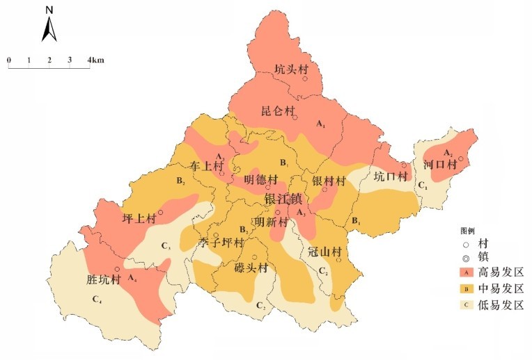
根据上述计算方法,得出各评价单元的地质灾害易发性综合指数。利用GIS软件,使用克里金(Kriging)插值方法生成等值线图。然后,结合实际情况,合并邻近类似单元,划定地质灾害易发区。