通过对融合多源遥感与云平台的水工环地质勘查新技术进行研究,利用多源遥感技术获取水工环地质数据,处理并提取关键遥感信息,完成对水工环地质问题的解译。基于基础设施云平台构建水工环地质信息云平台,云平台可存储与显示全部由多源遥感技术获取并解译的水工环地质问题,达到对水工环地质信息的社会化共享目的。结果表明:多源遥感技术的应用能够基本查明水工环地质构造分布特征,对各种类型的不良地质进行解译,水工环地质信息服务平台利用云计算、大数据等相关技术,可实现基于多源遥感技术解译的各类水工环地质数据的汇交与共享。
This paper studies the new technology of hydraulic environment geological survey integrating multi-source remote sensing and cloud platform. The multi-source remote sensing technology is used to obtain hydraulic environment geological data,process and extract key remote sensing information,and complete the interpretation of hydraulic environment geological problems. Based on the infrastructure cloud platform, the hydraulic environment geological information cloud platform is built, which can store and display all the hydraulic environment geological problems obtained and interpreted by multi-source remote sensing technology, so as to achieve the purpose of social sharing of hydraulic environment geological information. The results show that the application of multi-source remote sensing technology can basically identify the distribution characteristics of hydraulic environment geological structures and interpret various types of bad geology. By using cloud computing, big data and other related technologies, the hydraulic environment geological information service platform can realize the convergence and sharing of all kinds of hydraulic environmental geological data based on the interpretation of multi-source remote sensing technology.
引言
现阶段,很多国家水工环地质勘查工作已由以往以把握资源家底为主要目的的基础调查向以推动自然社会经济复合生态系统可持续发展为战略而有重点、针对性地解决社会发展与人类生存的重大问题转变[1] 。很显然,这一转变提高了对资源—环境—经济协调发展的重视,水工环地质勘查一体化成为重要发展趋势,呈现出信息量大以及功能多样化的态势,进一步对技术应用提出更高要求。为了更好推动水工环一体化以及地质行业的发展,保证能源开发与利用效率,并对社会经济以及环境的可持续发展形成推动,需要将新的更为有效的技术应用于水工环地质勘查中,本文对此展开研究。
1基于多源遥感技术的水工环地质问题解译
遥感技术[2] 特别是多源遥感技术[3] 表现出信息综合、大范围同步观测以及不受天气和地域干扰的优势,能够在水工环地质勘查中得到很好的应用。对此,对多光谱遥感、热红外遥感、雷达遥感、高分辨率遥感以及三维遥感等多遥感技术进行结合,基于综合判释方法的运用,可完成对水工环地质问题的解译。
1.1 确定遥感数据源
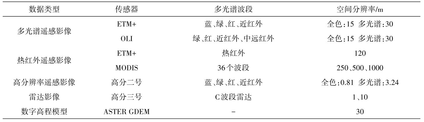
以水工环地质发育特征以及实际的勘测需求为依据,可对Landsat-7、Landsat-8卫星影像、高分二号(GF-2)卫星影像、高分三号(GF-3)雷达影像以及MODIS热红外影像等进行优先选用,执行对数字高程模型等数据的收集任务,如表1 所示,将相应的水工环地质遥感解释工作做好。
1.2 遥感数据处理及信息提取
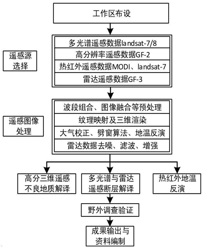
结合水工环地质勘查的具体内容,对多源多类遥感技术综合解译方法[4] 加以运用,开展水工环地质问题的勘查,图1 所示为信息提取技术流程。基于对遥感图像的处理,在多光谱遥感、雷达遥感以及高分辨率遥感结合方法的支持下,做好沿线断层遥感解译工作,实现对植被和河流覆盖等相关问题的解决;借助于高分辨率三维遥感技术,执行对崩塌或泥石流等不良地质的解译任务;通过对热红外遥感技术的运用,进行沿线高地稳定量反演等等。
(1)遥感图像预处理。针对已经收集到的各类遥感图像,执行波段组合、几何精校正、图像融合以及镶嵌等各项预处理任务。在进行多波段数据融合处理时, ETM+数据和CF-2数据分别对741 (RGB)以及321(RGB)组合方式加以采用;在执行对高低分辨率遥感数据的融合处理任务时,先将样区选取出来,之后采用学者刘桂卫和乔平[5] 提出的定量评价方法,针对主成分分析、IHS彩色变换、高通滤波变换以及小波变换等融合算法作出优选,进一步地,融合处理ETM+以及CF-2影像各自的多光谱与全色数据;因为GDEM数据有局部的高程异常现象存在,在运用此类数据之前,需要先对其进行转换,由点云数据表示出来,之后以限差为依据作拟合处理,达到将高程异常消除的目的,最后完成对DEM数据的重新生成。
表1 水工环地质勘查中应用的遥感数据源Table 1 Remote sensing data sources used in hydraulic environment geological survey
图1 水工环地质遥感技术路线Fig.1 Remote sensing technology route of hydraulic environment geology
(2)面向不良地质进行三维遥感解译系统的构建。以遥感正射影像以及DEM数据为基础,执行对它们的严格配准任务,同时,施以三维渲染,在三维表面对线路方案以及水工环地质资料等数据进行叠加处理,以三维地质遥感判释以及定量分析系统[6] 为支持,针对不良地质做好详细的解译以及分析工作。
(3)处理雷达数据。对高分三号分辨率为10 m的精细成像模式数据进行收集,在滤波、去噪、地理编码以及几何精校正等的基础上,进行后续水工环关键地质信息的提取。
(4)热红外遥感地温反演。先对图像亮度值进行转换,由热辐射强度值将其表示出来,之后对亮度温度以及大气等效温度等相关参数进行计算,完成对热红外遥感地温反演模型的构建。TM6热红外波段与MODIS数据分别对单窗算法以及劈窗算法加以运用,做好相应的低温定量反演计算工作。
2多源遥感解译数据的水工环地质信息平台构建
2.1 平台总架构
在利用多源遥感技术完成对水工环地质信息的收集及解译工作之后,需要对以下问题作重点考虑:①地质信息管理分散,在不同单位或平台上,相同数据的数据格式以及存储方法等可能会存在差异,要想在同一平台得到所需数据本就有较大难度,若是通过不同平台来获取,难度会更大;②因为数据格式、权限以及存储形式有不同的标准,要想采用统一方法执行对数据的挖掘和分析任务有较大难度;③不同信息系统之间虽然有类似功能,但相互之间是独立的,互操作难度非常大,不同水工环信息系统可能有较为明显的重复建设问题存在。
采取有效措施整合以上多源异构数据,达到社会化共享水工环地质信息的目的,对上述问题的出现加以规避,以此实现对政府、专业人员以及社会公众对水工环地质信息需求的有效满足是水工环地质领域需要着力解决的一项问题。对此,基于基础设施云平台(IaaS)[7] 进行水工环地质信息云平台的构建,借助于分布式数据及对象对结构化以及非结构化数据进行存储,在数据同步交换组件的支持下,达到对数据的收集目的,之后执行对统一基础平台的构建任务,对不同业务类型应用的开发及运行提供支持,图2 所示为平台整体架构。
借助于云平台IaaS,基础设施层发挥出基础运行、资源共享以及资源动态扩展的功能,同时,完成对虚拟网络环境的构建任务。数据层的数据以遥感监测为来源,基于对分布式架构的构建,执行对海量水工环遥感数据的存储任务,水平扩展为系统数据操作性能提供保证。另外,在数据同步和交换中间件的支持下,执行对不同监测机构数据的同步交换任务,确保数据源的足够丰富性。平台层面向各业务系统的共用部分,执行对它们的有效提取及融合任务,进行统一系统安全管理及服务管理的构建,提供相应的开发组件、数据服务以及计算资源调度等功能,对开发过程进行简化处理,确保系统有足够的一致性。业务层在服务层之上构建,针对地质灾害、地下水以及地质遗迹等各相关业务,与用户实际需求相结合,将资源信息查询、统计、数据下载等功能发挥出来。
图2 IaaS水工环地质信息服务平台整体架构示意图Fig.2 The overall architecture diagram of the IaaS hydraulic environment geological information service platform
2.2 平台功能体系
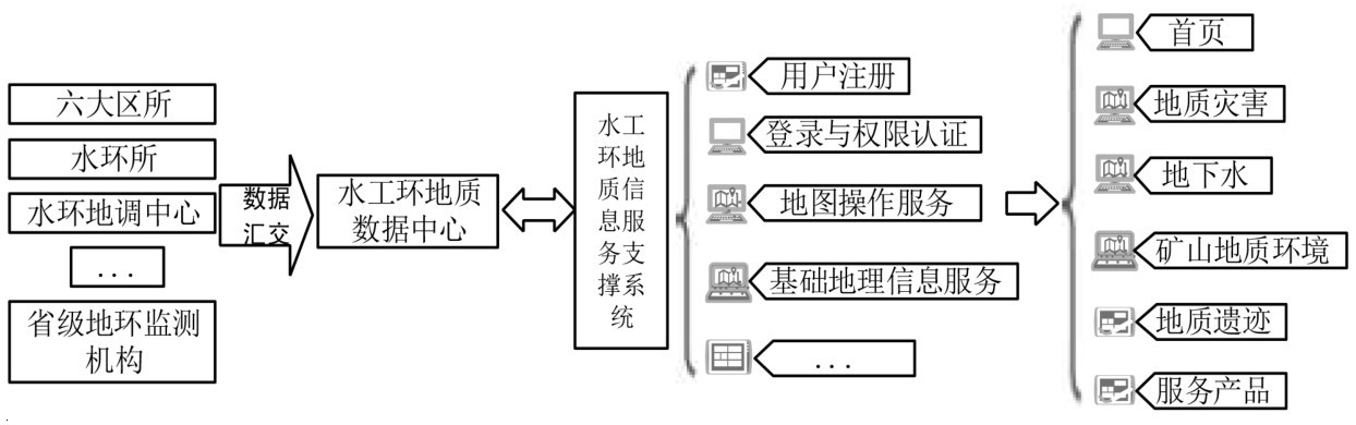
水工环地质信息大平台对“1+1+N”的模式加以采用(图3 ),执行软件系统的构建任务,其中,第一个“1”是指大数据管理系统,第二个“1”指的是信息支撑系统,“N”指的则是各种应用系统。大数据管理系统主要进行数据存储服务的提供,同时,还具有对数据的管理以及同步交换功能;信息支撑系统则具有统一登录认证、系统管理以及系统资源访问等功能;以大数据中心和信息支撑系统为基础,各应用系统为不同的业务领域提供服务,主要由地质灾害预警、地下水监测以及矿山数据管理等系统构成。
图3 水工环地质信息平台主要功能Fig.3 The main function of the hydraulic environment geological information platform
3 水工环地质信息平台及多源遥感解译实现
3.1 平台部署环境及其实现
iTelluro GIS是大型三维地理信息系统平台,该平台对面向Internet的分布式计算与三维可视化技术加以运用,能够为跨区域与跨网络提供支持,借助于该平台的扩展接口,开发人员能够便捷而又灵活地实现网络空间数据共享以及三维可视化。对此,水工环地质信息平台以iTelluro GIS为基础进行框架的开发,通过C#语言与Node.js编程来实现。为了保证数据有足够高的访问效率,在数据底层对Entity Framework与Dapper加以运用,前端页面访问层则采用Ajax等相关技术。整个水工环地质信息平台于IaaS之上进行部署,部署虚拟机设计空间服务服务器、基础支撑平台、数据中心和业务应用系统,数据库和存储分别进行一套分布式MySQL数据库、PsotgreSQL、InfoEarth ThingDB时序数据库和hadoop文件存储服务的布设。虚拟主机硬盘、内存以及CPU资源均能根据实际所需实现动态扩展,数据库节点亦具有水平扩展的功能。各项应用和数据库均在专有网络环境下建立,在用户访问Web服务主机中,进行公有IP的添加,根据不同的业务,基于Ngix代理节点的支持进行不同二级域名和SSL安全证书的添加,并完成对统一安全访问路径的建立。
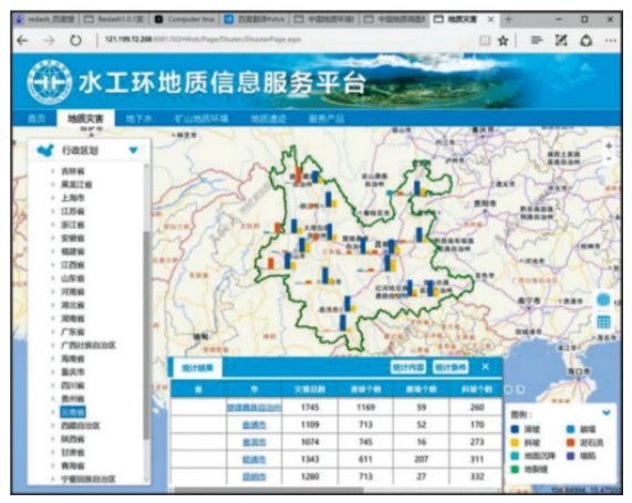
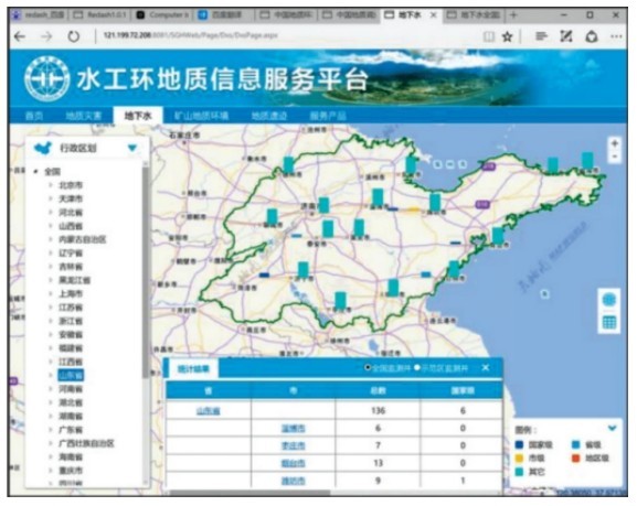
现阶段,以整体结构、功能体系和前述技术路线及选型为依据,能够实现对不同规模地质灾害、地下水、矿山、地质遗迹数据地质点以及相关监测数据与空间数据的集成整合,同时,大数据中心建设亦得以实现,由此而完成对基础支撑服务层与基于各大应用系统的开发。整个水工环地质信息服务平台由基础服务层与应用系统构成,其中,前者主要对安全管理服务、服务管理、空间数据服务、基础开发支撑组件库、中间件予以涉及,具有用户登录认证、服务监控等相关功能;后者则主要由地质灾害调查系统、群策群防系统、地质灾害预警系统、地下水监测业务系统、矿山信息管理以及地质遗迹管理等构成。图4 与图5 所示为平台部分界面。
图4 水工环地质信息平台地质灾害服务Fig.4 Geological disaster service of the hydraulic environment geological information platform
图5 水工环地质信息平台地下水数据服务Fig.5 Groundwater data service of the hydraulic environment geological information platform
3.2 多源遥感地质问题解译实例
水工环地质信息平台中对多种地质信息予以涉及,而这些地质信息建立于多源遥感技术对各种地质数据所作的收集以及地质问题的解译之上。此处运用实例对多源遥感地质信息的收集与解译水平和质量进行验证。以某艰险山区铁路地质勘查为例,为实现对勘查需求的有效满足,对多光谱遥感、高分辨率、三维、热红外以及雷达等多源遥感技术加以运用,执行对研究区域不良地质(如断层、崩塌等)以及高地温分布遥感解译任务。
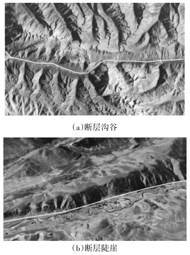
(1)断层解译。在遥感图像上,断层主要有线性行迹特征的表现,会借助于图像亮度或色彩的差异、地形的突变等完成表达。断层遥感解译标志主要包括断层沟谷、断层陡崖以及断层三角面等等。研究区域断层以断层沟谷与陡崖为其最为常见的解译标志,图6 所示为基于多源遥感技术提取的区域断层典型解译标志。其中,图6 (a)所示为断层沟谷的解译标志,表现出显著的方向性特点,既笔直又深切,宽度比较小;图6 (b)所示为断层陡崖的解译标志,断层对山体一侧进行切割,并由此形成陡崖,阴坡位置有一定程度的阴影形成。
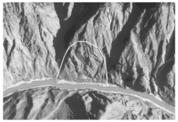
(2)崩塌三维遥感解译。对于铁路线路方案的设计而言,崩塌现象的发生会对其产生很大的威胁,对线路方案选择产生影响。研究区域处于陡坡地段,崩塌发育。在三维遥感空间场景中,崩塌以坡体表面的凹凸不平、粗糙感明显为其解译标志,此外,还有节理发育、植物稀少甚至是没有植被覆盖的表现,在坡脚位置,经常能够见到散落的崩塌体。图7 所示为崩塌的解译标志。
图6 断层遥感解译标志特征示意图Fig.6 Schematic diagram of remote sensing interpretation markers of faults
图7 崩塌遥感解译标志特征示意图Fig.7 Schematic diagram of remote sensing interpretation marker of landslide
(3)热红外遥感低温反演。对收集到的ETM+与MODIS热红外影像加以运用,进行研究区域地温遥感反演。根据ETM+热红外波段反演结果,太阳辐射在昼间会对地表温度产生很大的影响,对于不同地物而言,他们的温度有明显差异呈现出来,如山体阳坡与阴坡温度差异比较大,相较于基岩裸露区而言,植被覆盖区的温度要低一些,基底热异常信息的提取难度比较大(图8 )。进一步地,进行MODIS夜间成像热红外地温反演,达到对地物本底发热特征的探查目的,结果显示河流等水体有高温特征表现出来,因为MODIS影像的热工外波段没有很高的分辨率(1 km),导致一些出露面积比较小的地热异常点并未反映出来。对昼夜热红外地温反演结果进行综合能够知道,传感器、太阳辐射、地貌以及构造等会对地表热辐射产生较为明显的影响,基于热红外遥感反演技术的支持执行对地热异常的提取任务,要对上述因素进行全面把握。
图8 热红外遥感地温反演结果Fig.8 Geothermal inversion results of thermal infrared remote sensing
此部分基于对多源遥感技术的运用对某山区铁路沿线地质问题进行遥感解译,实现了对500余条断层的解译,且基本将铁路沿线构造分布特征查明,此外,还完成了对超过150处不良地质的解译,这些数据全部上传至水工环地质信息平台并实现了共享,为重要项目的方案必选提供了重要的参考依据。
4 结语
水工环地质勘查长期以来一直是我国的重要建设内容,作为一项基础性的工作,对工程的顺利与高效完成发挥着尤为重要的作用。本文研究一种对多源遥感、和云平台进行融合的新型水工环地质勘查技术,并验证其设计有效性。在技术的有效运用下,水工环地质环境所受损害可以得到较好的控制,不仅如此,亦能达到有效节省勘查时间的目的。今后,还需进一步与当前水工环地质勘查工作及服务需求的实际情况相结合,进行水工环地质技术研究及应用的进一步完善,为整个地质勘查工作的高效开展以及信息化建设作贡献。
表1 水工环地质勘查中应用的遥感数据源Table 1 Remote sensing data sources used in hydraulic environment geological survey 图1 水工环地质遥感技术路线Fig.1 Remote sensing technology route of hydraulic environment geology 图2 IaaS水工环地质信息服务平台整体架构示意图Fig.2 The overall architecture diagram of the IaaS hydraulic environment geological information service platform 图3 水工环地质信息平台主要功能Fig.3 The main function of the hydraulic environment geological information platform 图4 水工环地质信息平台地质灾害服务Fig.4 Geological disaster service of the hydraulic environment geological information platform 图5 水工环地质信息平台地下水数据服务Fig.5 Groundwater data service of the hydraulic environment geological information platform 图6 断层遥感解译标志特征示意图Fig.6 Schematic diagram of remote sensing interpretation markers of faults 图7 崩塌遥感解译标志特征示意图Fig.7 Schematic diagram of remote sensing interpretation marker of landslide 图8 热红外遥感地温反演结果Fig.8 Geothermal inversion results of thermal infrared remote sensing