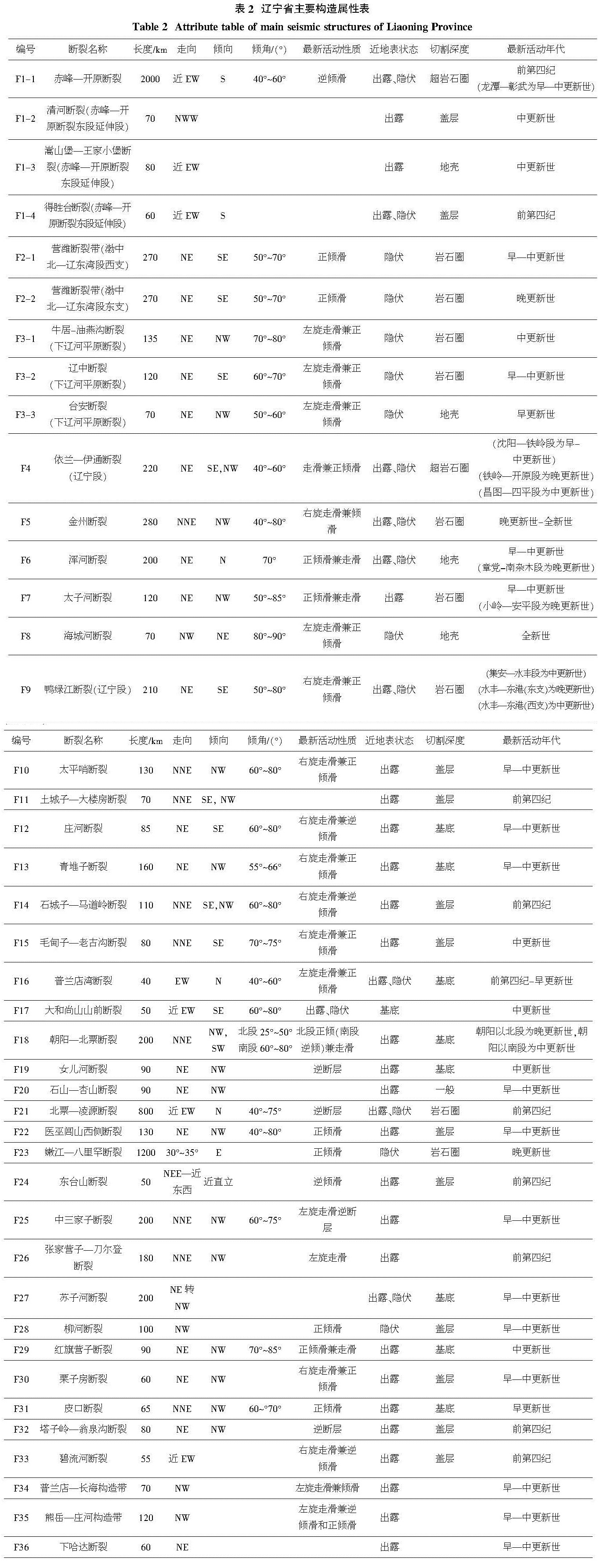
在编图过程中,根据历史资料记载和新成果的汇总,共列出辽宁地区具有一定规模的(长度大于30 km)、活动性较强的断裂共42条,包括对中强震有控制作用的13条主要地震构造,主要有:依兰—伊通断裂(辽宁段)、海城河断裂、金州断裂、下辽河平原断裂、鸭绿江断裂等等。区域水平构造应力场主压方向为 NEE 向。
按照展布特征划分为近东西向、NE—NEE向、NW向和近南北向四组,NE—NEE向断裂最为发育。从区域构造演化来看,近东西向断裂形成最早,是伴随结晶基底的褶皱回返过程而产生的,多为平行于褶皱轴的压性断裂,受后期错切或岩浆岩充填,完整性较差;NE—NEE向断裂最为发育、延续性最好,对早期盖层分布有一定控制作用,中生代断陷盆地发育,压扭性挤压破裂带规模巨大,第四纪时期活动水平仍然较高,对区域地震活动具有控制作用;近南北向断裂形成较早,新生代以来活动不明显;NW向断裂多数规模不大,但第四纪时期活动强烈,常常切割其它走向的构造,多中强震发生。如表2:
表2 辽宁省主要构造属性表
Table 2 Attribute table of main seismic structures of Liaoning Province
在上一版地震构造图的基础上,本图录入的活动断裂增加至42条,录入的数据信息有断裂名称、长度、走向、倾向、最新活动性质、近地表状态、切割深度、活动年代等9项属性。随着省内活断层探测工作的不断深入,形成了大量的新认识和新观点,为了将新成果更好的展示,本图就活动断裂的长度、分段方法、活动性质、活动时代等进行了实时更新。如下:
(1)对部分活动断裂长度进行了更新,如F5金州断裂,北端由鞍山延伸到了辽阳县,对于是否延伸到辽阳市北还处于研究中,本图采用前者;再如F17大和尚山前断裂由起初测定的35 km延长至50 km。
(2)对部分活动断裂的分段节点进行了修正,如F5金州断裂,是辽东半岛最大的区域性断裂,前人在研究中采用两分法,以九寨节点,分为南、北段,为了进一步研究其构造特征,本图将其分为四段,分别为金州—普兰店段、普兰店—九寨段、九寨—盖州北段、盖州北—鞍山段。F9鸭绿江断裂以水丰为界,由原来的南、北两支修正为东、西两支。F18朝阳—北票断裂由原来的北、中、南三段修正为以朝阳为节点的南、北两段。
(3)对于活动时代进行了更加细化的研究,如F1赤峰—开原断裂最新活动时代为前第四纪,通过分段研究,获得了龙潭—彰武段为早—中更新世断裂的系列证据。再如F28柳河断裂最初认为其最新活动时代为中更新世,通过后续探测获得了早更新世的证据。再如F7太子河断裂、F6浑河断裂分别为前第四纪和早—中更新世断裂,经研究发现在两个断裂中分别存在小岭—安平段、章党—南杂木段的晚更新世断裂。
(4)新增断裂一条,F36:下哈达断裂。初步认为该断裂系赤峰—开原断裂东段延伸段,具体内容尚在研究中。表2为本图活动断层的属性信息,对于部分尚未明确的属性信息在后续探测工作会持续更新。
主要活动断裂简介:
(1)F2: 营潍断裂带(渤中北—辽东湾段)。营潍断裂带渤中北—辽东湾段展布于辽东湾及渤海海域,由四条平行断裂组成,总长度约300 km,宽约50~100 km,主要划分为东、西两支,由许多次级断裂斜列组合而成,单段规模一般为25~30 km。断裂处在新构造下辽河—辽东湾沉降区内,断裂两侧差异性构造运动显著,重、磁异常明显,在NEE向近水平的挤压应力作用下,倾滑运动明显,第四纪断陷幅度较大。资料显示东支断裂的活动时代较新,其最新活动时代应为晚更新世,西支断裂活动性较东支为弱,最新活动应在晚更新世以前。营潍断裂带渤中北—辽东湾段地震活动相对频繁,记载有1次 级左右地震和多次5级左右地震,小震活动较多,最大地震为1922年
 级[17-18]。
(2)F4:依兰—伊通断裂(辽宁段)。断裂南起苏家屯,北至辽吉边界,总长220 km,走向NE—NEE,主体由东、西两条近平行断裂组成。新近纪以来,断裂活动强烈,两侧差异升降运动明显。自SW向NE分为南(沈阳—铁岭段)、中(铁岭—开原北段)、北(昌图—四平段)三段,南段被晚更新世坡积、冲积物平整覆盖,北段完整出露,活动时期均为为中更新世,历史记载1765年在沈阳发生过1次 级地震,其后未发生过5级以上的地震[13,19-20]。中段对晚更新世堆积物分布具有控制作用,铁岭红光村实测剖面显示,断裂错动了晚更新世断面充填物,表明最新活动时期为晚更新世,该段1875年之前,共发生过4次5级左右地震,近期小震活动也较频繁,仪器所记录到的ML≥1.8级地震30多次,是活动性最高的一段。
(3)F5:金州断裂。金州断裂是纵贯辽东半岛的区域性大断裂,延北东走向由2~3条分支断裂组成,派生众多构造发育,全长280 km,控制着整个辽东半岛的新构造运动格局。金州断裂与多条NW向构造之间具有共轭破裂特征。资料显示,沿断裂发现多处未固结的断层泥,七里村基线场内最大断层泥宽3.4 m,鉴定结果显示,断裂各段在早更新世均有明显活动,中、晚更新世在部分地段有活动,因此判定该断裂最新活动时代为晚更新世[21-23]。沿断裂有近10次 ~6级中强地震发生,1975年海城7.3级地震也位于断裂附近,各段也都发生过5级以上的地震。金州断裂自南向北可划分为金州—普兰店段、普兰店—九寨段、九寨—盖州北段和盖州北—鞍山段等4个段落,每段规模一般为50~80 km,并由多条次级断裂斜列组合而成,九寨—盖州北段和盖州北—鞍山段活动程度比较强烈。
(4)F8:海城河断裂。海城河断裂长度约70 km,主要处于隐伏状态,由一系列近平行或斜列状的NW向断裂构成,宽度一般为几公里至十几公里,与NNE向的金州断裂、NE向的鸭绿江断裂等具共轭交叉的结构特征。在地貌上控制了海城河及SE侧的大洋河等河流的发育。海城河断裂是1975年海城7.3级地震的发震断裂,属于全新世活动断裂,也是辽宁省及附近地区活动性最强的地震构造之一[24-25]。沿海城河断裂的重力异常等值线在在NE-NNE向突然发生强烈扭曲和畸变,呈NE-NNE向延伸的地壳等厚线在海城河断裂出现局部不均匀的转折变化,深部构造条件复杂。沿断裂地震分布极为密集,强度大,频度高,除了发生过7.3级地震外,还发生过多次5级以上强余震,近期小震活动十分频繁,形成密集的地震条带和团簇状分布,是区内地震活动水平最高的断裂构造。
(5)F9:鸭绿江断裂(辽宁段)。鸭绿江断裂北起吉林临江,延鸭绿江经集安、丹东入海,陆域长度约300余公里,控制着鸭绿江的总体走向,沿江两侧盆地发育。破碎带规模大,沿沟谷凹地延伸,带宽80~100 m。断裂经历了多期回旋演变,第四纪以来有过强烈运动,断层陡崖,碎裂岩、断层泥等清晰可见。在水丰以南,鸭绿江断裂分为东、西两支,东支断裂和西支断裂的东港以南段、水丰—东港段为主要的地震构造(段)。东支断裂以单断裂为主,地貌上线性特征明显,在下河口、古楼等地发现灰白色断层泥,测龄结果为中更新世活动提供了直接证据。西支以多支断裂为主,在东沟附近断层泥宽20 m,测龄结果显示该段最新活动时期为晚更新世,断层两侧分布四级海蚀阶地,北西侧高于南东侧,存在4 m高差,最低阶地形成于晚更新世。1916、1917、1944 年在鸭绿江口分别发生 MS5.4、6.1、 级地震,沿断裂小震活动较多[13,26-27]。
(6)F18:朝阳—北票断裂。朝阳—北票断裂是辽西地区一条主要的NNE向区域性断裂,大致由2~4条近于平行、断续相接的走滑断裂组成,全长约200 km。断裂线状影象清晰,地貌标志明显,断裂地表形迹清楚,断层泥发育。断裂朝阳以北段呈反S状弯曲,呈不规则的串珠状,朝阳以南段基本呈直线状延伸,北段的活动水平要明显地高于南段。断裂控制了沿线黄花营子、朝阳、冯杖子等小型第四纪沉积盆地的形成和发育。朝阳—大凌河剖面结果显示,晚更新世地层和老的断层面之间呈平直新断面接触,并发育断层泥,测年结果显示朝阳—北票断裂最新活动时期为晚更新世[13]。沿该段断裂曾发生过419年MS 级地震和1977年MS3.8级矿震,2016年在断裂附近发生朝阳MS4.6级双震和喀左MS3.8级地震,沿断裂微震密集成带分布。而在北票附近的地震多数为矿震。
断裂被辽宁地区也是第四纪盆地构造发育的地区,包括下辽河盆地、熊岳盆地、阜新—义县盆地、金州盆地、东港盆地、新义州盆地、庄河盆地、抚顺盆地、开原盆地、宁城—平庄盆地、松辽盆地和盖州盆地、辽阳盆地等。这些盆地往往受一组或多组断裂控制,长轴方向与区域构造线方向一致,各盆地的生成和发展与控盆断裂的活动特征密切相关,并与地震活动有着密切的关系。研究表明,这一地区的第四纪盆地一侧或两侧常发育走滑断层、逆冲断层和推覆体构造等。盆地及周围地区地震活动频度较高,强度较大,一些5级以上的地震多沿这些盆地的边缘分布。
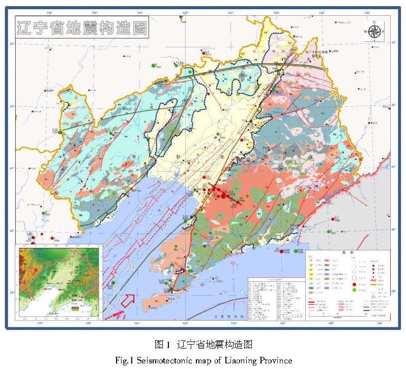
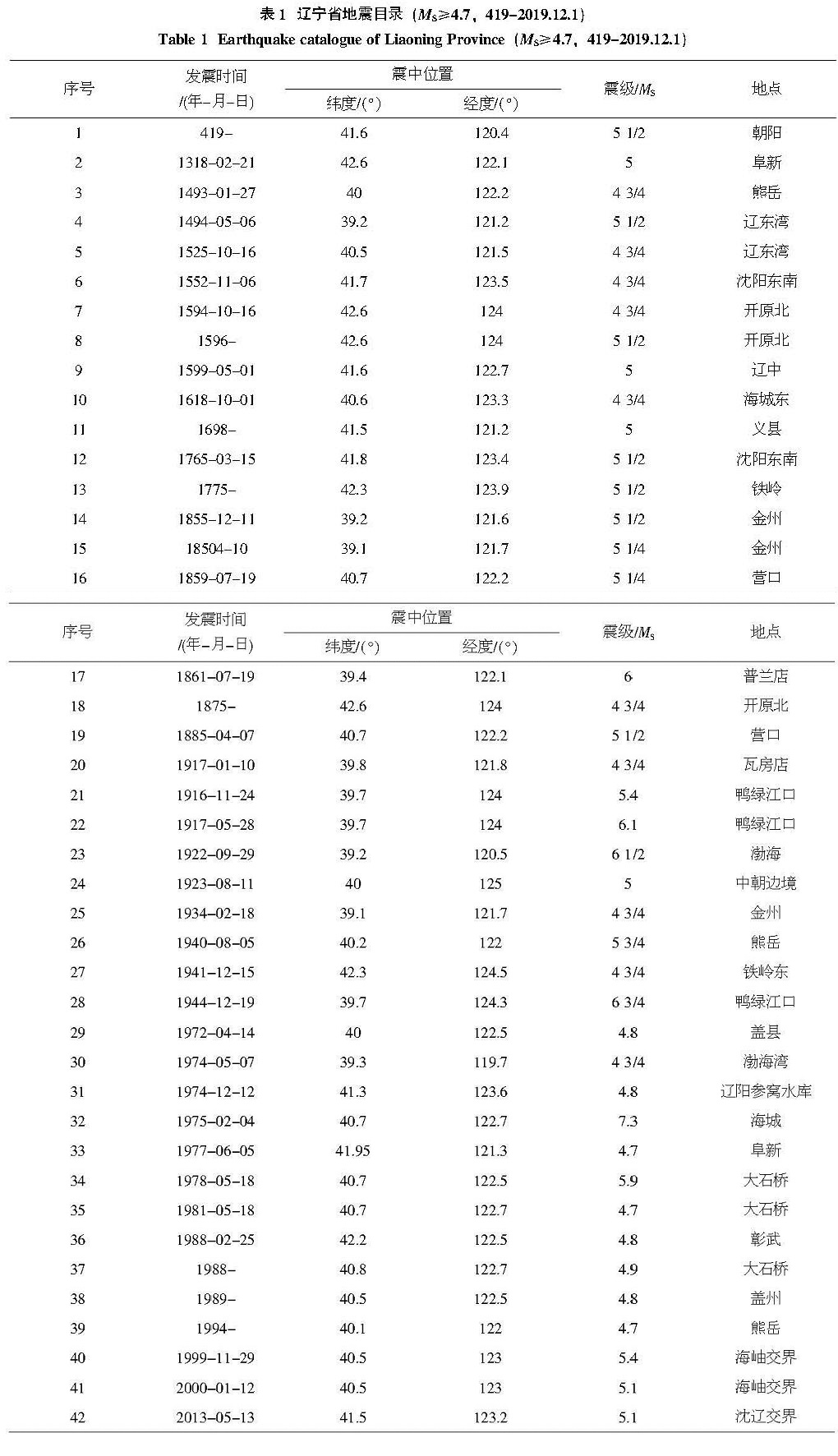
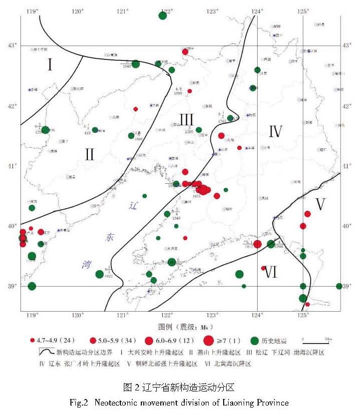
 级地震至今,共发生破坏性地震约42次(未包含大地震的余震),其中4.7~4.9级18次、5.0~5.9级19次、6.0~6.9级4次、7.0级以上1次。最大地震是1975年海城7.3级地震。1999年在岫岩地区连续发生4~5级中等地震震群。2012年以来进入新的活跃阶段,先后经历了盖州4级显著震群、庄河近海4.3级地震、灯塔5.1级地震、科尔沁(阜蒙交界)5.3级地震、海城4.4级地震等。从震源深度分布看,均为地下5~15km的浅源地震。从空间分布看,破坏性地震主要沿营口—海城—沈阳一线大范围集中分布;在金州、普兰店地区,鸭绿江口地区小范围带状分布;在辽西呈零散分布,破坏性地震受郯庐断裂、海城河断裂、金州断裂和鸭绿江断裂等主要活动构造控制;另一方面,在断裂构造交汇部位(以NE-NNE向、NW向居多)第四纪盆地发育,在构造盆地内部及其边缘地带地震活动较多,特别是5级左右的地震具有原地重复发生的特征。20世纪以来该地区地震活动明显增强,地震频率渐趋频繁,中小震群较为活跃。目前地震活动主要集中在海城老震区、盖州—庄河地区、鸭绿江口、朝阳地区和辽蒙交界的科尔沁地区。