重大水利水电、交通及城市地下空间工程的建设,正面临日益复杂的水工环地质条件,精细勘查隐伏断裂、岩溶、破碎带等不良地质体,是保障工程安全的核心前提。常规钻探与二维物探手段在描述这些地质体的精细空间展布与连通性方面存在固有局限性。三维地震技术凭借其高分辨率、三维“体”成像及多属性分析优势,为水工环地质勘查提供了革命性工具,但其应用方法学尚待系统化。从岩石物理学入手,系统分析典型不良地质体及水文地质结构的地震响应机理与波组特征针,对水工环勘查的浅层、小尺度目标,提出了包含高分辨率处理、地震属性优选与“井—震”结合的三维地质解译流程。在此基础上构建地质灾害评估框架,旨在为三维地震技术在重大工程选址、设计与风险管控中的深化应用提供方法论支撑。
The construction of major water conservancy and hydropower, transportation, and urban underground space projects is facing increasingly complex hydrogeological and environmental geological conditions. Fine explora‐tion of unfavorable geological bodies such as hidden faults, karst formations, and fractured zones is the core prereq‐uisite for ensuring project safety. Conventional drilling and 2D geophysical methods inherently struggle to character‐ize the fine-scale spatial distribution and connectivity of these geological bodies. 3D seismic technology, with its ad‐vantages of high resolution, 3D volumetric imaging, and multi-attribute analysis, provides a revolutionary tool for hy‐drogeological and environmental geological surveys, yet its application methodology needs to be systematized. Start‐ing from rock physics, this paper systematically analyzed the seismic response mechanism and wave group character‐istics of typical unfavorable geological bodies and hydrogeological structures. Aiming at the shallow and small-scale targets of hydro-environmental geological exploration, a 3D geological interpretation workflow incorporating high-res‐olution processing, optimized seismic attribute selection and borehole-seismic joint interpretation was proposed. On this basis, a geological hazard assessment framework was established to provide methodological support for the in-depth application of 3D seismic technology in site selection, design and risk management of major engineering proj‐ects.
引言
我国正处于基础设施建设的高峰期,以大型水利水电枢纽、深埋长隧道、跨海桥隧及城市地下空间开发为代表的重大工程,其规模、埋深和建设环境的复杂性均达到了前所未有的高度。工程建设活动与地质环境的相互作用空前剧烈,对工程选址、设计和长期运营的地质安全性提出了远超以往的严苛要求[1] 。水工环地质问题是制约重大工程安全的核心瓶颈。与常规土木工程主要关注均质地基不同,重大工程面临的地质挑战高度复杂且极具隐蔽性。如隐伏的活动断裂、岩溶洞穴与暗河、深部破碎带、高压富水区以及古滑坡体、软弱夹层等不良地质体,构成了工程灾害的主要孕灾源头[2-3] 。传统的地质勘查范式,主要依赖于钻探到槽探再到二维物探(深线)的组合。钻探作为最直观的手段,可获取高精度的原位信息,但其本质是“以点带面”的稀疏采样。面对空间上急剧变化、形态极不规则的地质体,钻孔的“可见即所得”特性使其极易产生“漏判”和“误判”[4] 。
高分辨率三维地震勘探技术,源于石油天然气工业,其核心优势在于能够对地下数公里范围内的地质构造和地层进行密集、无间隙的“CT式”扫描,获得高精度的三维地质数据体。近年来,随着采集设备的进步和处理算法的发展,该技术正逐步从深层油气勘探转向地壳浅层(0~2000 m)的工程与环境领域[5-6] 。综上,水工环地质勘查的精细化和三维透明化需求,与三维地震技术的高分辨率和体成像能力之间,存在着天然的契合点。然而,将成熟的油气地震勘探方法论直接“降维”应用于地质条件截然不同的水工环领域,面临着一系列严峻的技术挑战。因此,文章就基于三维地震资料的水工环地质勘查与灾害评估展开研究,以期望为相关领域提供一定的理论支持和实践指导。
1 水工环地质要素的地震响应机理
三维地震勘探技术能否成功应用于水工环地质勘查,其物理根基在于水工环领域所关注的地质要素能否引起围岩岩石物理参数的规律性变化,并进而产生可被地震波场识别和捕捉的响应特征。
1.1 岩石物理参数与水工环地质要素的关联性
岩石物理学是连接地质参数与地球物理参数的桥梁。在地震勘探中,最核心的岩石物理参数是声阻抗(Z)、纵波速度(VP )、横波速度(VS )和密度( ρ )。其中,声阻抗( Z=ρV P )是控制地震反射强弱的决定性因素。两个不同地质介质(Z1 和Z2 )之间的反射系数R可近似表示为:
式(1)中,R的绝对值越大,反射能量越强,地震剖面上表现为越明亮的同相轴。
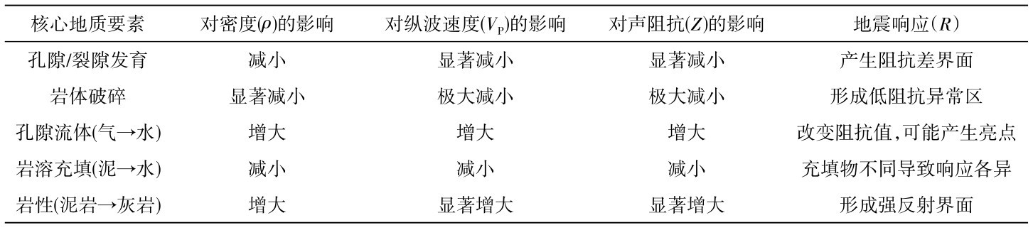
表1 水工环地质要素对核心岩石物理参数的定性影响Table 1 Qualitative influence of hydro-environmental geological geological elements on core rock physical parameters
如表1 所示,水工环地质要素,特别是岩性、孔隙(裂隙)发育程度和流体性质,正是通过改变岩石的密度ρ和弹性模量(进而改变VP ),从而根本上改变了声阻抗Z及其空间差异,使精细地质勘查成为可能[7] 。岩性是基础控制因素。不同岩石因其矿物成分、成岩过程与胶结程度的巨大差异,具有截然不同的密度ρ和弹性模量,因此其VP 和Z值天然存在差异,这是地层划分和岩性识别的地震学基础。孔隙与裂隙是工程地质的核心关注点。孔隙和裂隙的存在,首先会以充填物(通常是水或空气)取代高密度的岩石骨架,导致岩石整体密度ρ降低;它们极大地削弱了岩石的整体刚性,即弹性模量(特别是体积模量K和剪切模量μ)急剧下降。这导致VP 和VS 显著降低,从而使Z值大幅减小,形成与围岩的阻抗差异。流体是水工环问题的关键。根据Gassmann方程所揭示的机理,孔隙中充填的流体类型对岩石的体积模量K有显著影响,但对剪切模量μ几乎无影响。
1.2 典型不良地质体的地震波组特征
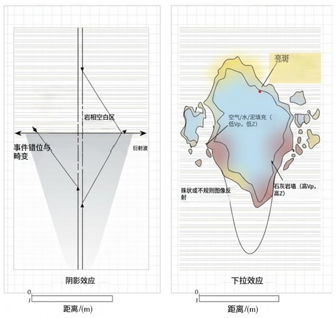
基于上述岩石物理机理,水工环领域关注的典型不良地质体因其物性参数与围岩存在显著差异,会表现出特定的地震波组特征。断裂与破碎带:断裂是重大工程的“红线”。其地震响应并非一条简单的“线”,而是一个复杂的“带”。在地震剖面上,断裂带通常表现为:①同相轴的错断与扭曲:这是断裂两侧地层发生相对位移的直接反映;②反射能量的衰减与空白带:断裂破碎带内部岩石破碎、结构松散,导致声阻抗Z极低(如表1 所示),且对地震波具有强烈的吸收衰减(高Q值)和散射作用。这使得破碎带自身表现为杂乱反射或反射“空白”区域,同时其下方的地层反射能量也会变弱,形成“阴影效应”;③绕射波:断裂面的端点和地层的错断点会产生强烈的地震绕射波,表现为双曲线形态的绕射波组[8] 。在三维数据体上,断裂带在沿层相干属性切片上表现为低相干值的线性或条带状异常。当岩溶洞穴尺度大于地震波长的1/4时,可被有效识别。其典型特征(如图1 所示)包括:①强振幅反射:洞穴充填物的声阻抗Z2 与围岩(灰岩,高Z1 )差异极大,导致在洞穴顶、底界面产生极强的反射(R绝对值大)。若充填物阻抗极低,可能导致反射极性反转;②串珠状或不规则反射:若岩溶沿层发育或呈管道状,则强反射体呈串珠状断续出现;③同相轴下拉:洞穴充填物的VP 远低于围岩,地震波穿过时产生时滞,导致洞穴下方的地层同相轴出现“下陷”的假构造现象;④绕射波组:洞穴的边界是强烈的点绕射源,产生显著的绕射波[9] 。
图1 典型不良地质体地震响应模式示意图Fig.1 Schematic diagram of seismic response patterns of typical unfavorable geological body
1.3 水文地质结构的地震反射模式
水文地质结构勘查的核心是识别含水层与隔水层的组合关系,以及查明导水通道。其地震反射模式主要依赖于地震相与振幅异常。在层状地层中,含/隔水层系统的识别依赖于反射模式的差异。隔水层沉积环境稳定,通常表现为高连续性、高频率、平行的反射特征。而含水层沉积环境能量高、变化快,常表现为中—低连续性、变振幅的反射,并可能伴随前积、透镜状等特定沉积相[10] 。二者在反射结构上的清晰差异,是圈定承压含水层的地震学基础。导水通道的识别则更依赖于局部异常。富水断裂的充水介质改变了其岩石物理参数,与围岩形成新的阻抗差异,常在地震剖面上沿断裂带表现为“亮点”或“暗点”等振幅异常。砂砾质古河道作为重要的导水通道,其高孔隙充填物与两侧的黏土存在显著阻抗差异。在三维地震数据体的时间或沿层切片上,常显现为具有高振幅异常的、清晰的弯曲带状地貌形态。
2 面向水工环勘查的三维地震解译方法
水工环目标体具有浅层、小尺度、非均质性强、物性差异多变的特征,这要求解译方法必须具备更高分辨率、更强的针对性与更精细的“井—震”结合能力。
2.1 针对浅层、小尺度目标的高分辨率资料处理策略
油气勘探关注的深层(>2 km)大型构造目标与水工环勘查关注的浅层(0~1000 m)小型地质异常体(如米级岩溶、断层破碎带)在尺度和埋深上存在巨大差异。因此,常规的油气地震资料处理流程必须进行针对性优化,其核心策略是“保高频、求精细、提信噪”。首先,高精度的近地表速度模型与静校正问题是浅层勘查的重中之重。近地表介质的强非均质性会导致严重的波形畸变和同相轴错断,常规折射静校正难以满足要求,必须采用层析静校正、模型静校正乃至波动方程基准面校正等高精度方法,为浅层高分辨率成像奠定基础。其次,为保证对“小尺度”目标的识别力,必须全程贯彻“保高频”策略。最后,偏移成像是决定成像质量的关键[11] 。针对水工环领域常见的陡倾角断裂、不规则岩溶边界及强散射体,简单的叠后偏移已不足以精确成像。
2.2 地震属性优选与地质体识别技术
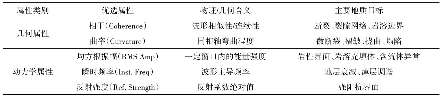
三维地震数据体蕴含着丰富的波形信息,单一的振幅剖面难以揭示所有隐伏的地质异常。地震属性技术是将地震波的动力学与运动学信息进行定量化提取的工具,是识别特定地质体的“放大镜”。针对水工环地质勘查,属性优选应聚焦于表征“不连续性”、“形态变化”和“物性差异”(表2 )。
表2 水工环地质勘查的优选地震属性及其地质含义Table 2 Preferred seismic attributes for hydro-environmental geological exploration and their geological implications
几何属性是识别构造与破碎带的首选。其中,相干/方差属性对波形相似性极为敏感,能够清晰地勾勒出断裂、裂隙网络、岩溶边缘等地质不连续面,在三维切片上表现为低相干的线性或片状异常[12] 。曲率属性则擅长揭示同相轴的细微弯曲,对识别常规剖面上难以察觉的微小断层、褶皱、地层挠曲以及岩溶塌陷相关的上覆地层形变尤为有效。动力学属性则侧重于反映物性差异。振幅类属性是反映声阻抗差异最直观的指标,可用于识别岩溶充填体、含水异常及岩性接触界面。频率类属性则对介质的吸收特性敏感,可用于辅助识别破碎带或薄层调谐。
2.3 “井—震”结合与三维地质建模技术流程
三维地震资料提供了连续的地球物理“体”信息,而钻孔资料则提供了高精度的“点”状地质标定。水工环地质勘查的最终成果必须是工程可用的地质模型,决定了“井—震”结合是实现从地球物理响应向地质参数转译的唯一路径,其核心逻辑是“以井标震、以震控井”。
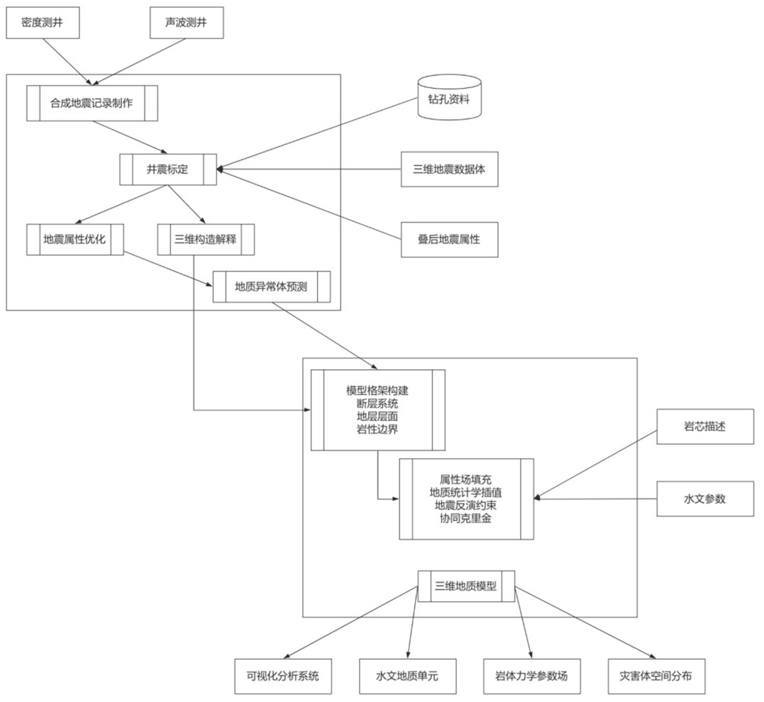
如图2 所示,该流程始于精确的“井—震”时深标定,即利用钻孔测井数据制作合成地震记录,将其与井旁地震道对比,建立可靠的时深关系,这是实现地质分层与地震同相轴准确对应的基石。在此约束下,进行构造—层位解释,系统追踪断裂与关键地层界面。随后,以钻孔揭示的岩溶、断裂等异常点为“种子”,分析其在优选地震属性上的响应“指纹”,并利用此“指纹”在三维数据体中追踪和预测同类地质异常体的空间展布。最后,将所有解释的断层格架、地层层面和预测的地质体导入建模软件,构建三维地质格网,并以钻孔数据为硬约束,通过地震反演或地质统计学方法将岩体力学、水文地质参数填充到模型中,形成可视化、可量化的三维水工环地质模型。
图2 “井—震”结合的三维地质建模技术流程Fig.2 Three-dimensional geological modeling technology workflow of borehole-seismic joint interpretation
3 基于三维地震解译的地质灾害评估框架
3.1 场地工程地质稳定性评估路径
重大工程的场地稳定性,深受岩体力学性质、不良地质体空间展布及结构面控制。基于三维地震资料的稳定性评估路径,核心在于实现从“地球物理模型”向“岩土力学模型”的转化。上文构建的三维地质模型提供了场地内断裂、岩溶、破碎带及软弱夹层等关键地质体的精确三维空间几何约束,包括其产状、规模、连通性及空间叠置关系。利用“井—震”结合标定,将钻孔测井与岩石力学试验获取的“点”状参数与三维地震属性建立定量或半定量的统计关系。通过地震反演或地质统计学方法,可将这些岩体力学参数“插值”扩展至三维地震格网中,生成三维岩体力学参数场。最后,该参数场可直接作为输入,导入有限元(FEM)或离散元(DEM)等数值模拟软件中。
3.2 构造活动性与地震地质灾害危险性分析
三维地震资料为评价构造活动性与地震地质灾害提供了前所未有的高精度几何约束。其分析框架首先聚焦于活动断裂的精细识别与刻画。三维地震数据体能够清晰揭示断裂系统的三维空间构型、分段特征、组合样式及其与浅部地层的切割关系。断裂是否切割上覆晚近地层是判定其新构造活动性的直接地震证据。尽管地震资料本身难以确定断裂的最新活动年代,但它能精确圈定断裂在地表的潜在出露位置或隐伏断裂的上顶托点,为地质灾害“避让带”的划定提供最直接的几何依据。在此基础上,地震地质灾害危险性分析得以展开:一方面,三维地震模型可用于评估潜在的“地表破裂”危险区;另一方面,该模型可作为输入,用于(PGA)等地震动参数的场地响应模拟,分析局部场地条件(如软土、基岩起伏)对地震动的放大效应。
3.3 水文地质灾害风险评价方法
水文地质灾害的发生,取决于“致灾水源”、“导水通道”和“工程目标”三要素的空间配置关系。三维地震勘查的核心优势在于其能够同时精细刻画这三要素,从而建立风险评价方法。该评价方法首先应建立三维水文地质结构模型。基于上文分析,在三维空间中圈定主要含水层和隔水层的展布、厚度与接触关系。其次,利用相干、振幅等属性,精细刻画潜在的“导水通道”,包括富水断裂带、岩溶管道、导水陷落柱或砂砾石古河道等。三维地震资料对这些通道“连通性”的展示是二维物探无法比拟的。最后,进行风险评价。该评价的核心是分析三者间的“空间邻近性”与“水力连通性”。
4 结论与展望
4.1 主要研究结论
本文针对重大工程建设中迫切的水工环地质精细勘查需求,系统探讨了三维地震技术由油气勘探向工程地质领域应用的方法学问题,构建了从机理分析、解译流程到灾害评估的框架。三维地质模型是实现定量灾害评估的“几何”与“参数”基础。本文构建的灾害评估框架,实现了从静态地质模型到动态灾害评价的跨越。框架将三维地震解译的几何模型和参数模型作为数值模拟和空间分析的输入,为场地稳定性、地震地质灾害和水文地质风险的定量化评价提供了实现路径。
4.2 技术应用的局限性、不确定性与未来研究方向
尽管三维地震技术为水工环地质勘查提供了强大的工具,但其应用仍受限于客观物理规律和工程实际,存在局限性与不确定性,亟待在未来研究中深化。技术应用的局限性主要体现在分辨率与成本。地震勘探的垂向和横向分辨率受限于地震波长,对于尺度小于四分之一波长的地质体难以有效识别,存在勘查盲区。另外,解译结果的不确定性与多解性不容忽视。近地表介质的强非均质性对浅层地震波的激发、传播和接收均造成严重干扰,导致浅层成像信噪比和保真度降低。
展望未来,三维地震技术在水工环领域的发展应聚焦于以下方向:一是深度融合与约束反演,即突破单一地震技术的局限,将三维地震与钻探、测井、高密度电法、重力等多元地质-地球物理信息进行联合反演,以最大限度地降低解译的多解性;二是定量化与智能化解译,即从定性的形态学描述转向定量的岩体力学、水文地质参数反演;并利用深度学习等人工智能技术,实现对海量三维数据体中不良地质体的自动、高效识别。
表1 水工环地质要素对核心岩石物理参数的定性影响Table 1 Qualitative influence of hydro-environmental geological geological elements on core rock physical parameters 图1 典型不良地质体地震响应模式示意图Fig.1 Schematic diagram of seismic response patterns of typical unfavorable geological body 表2 水工环地质勘查的优选地震属性及其地质含义Table 2 Preferred seismic attributes for hydro-environmental geological exploration and their geological implications 图2 “井—震”结合的三维地质建模技术流程Fig.2 Three-dimensional geological modeling technology workflow of borehole-seismic joint interpretation