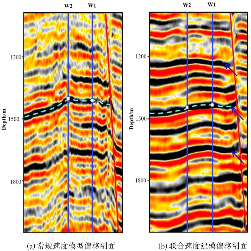
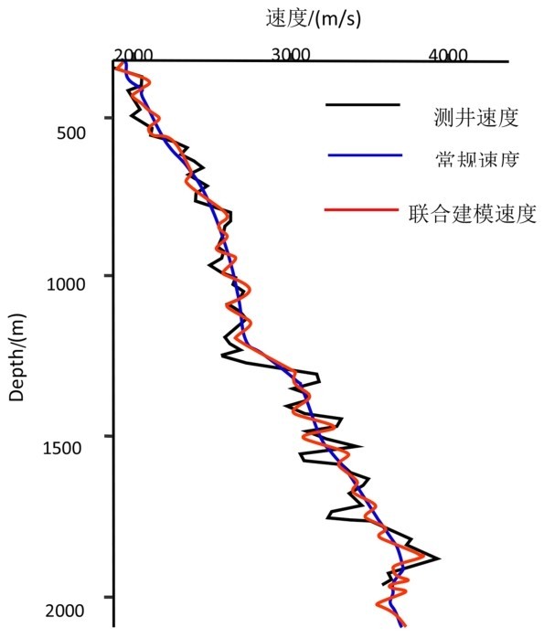
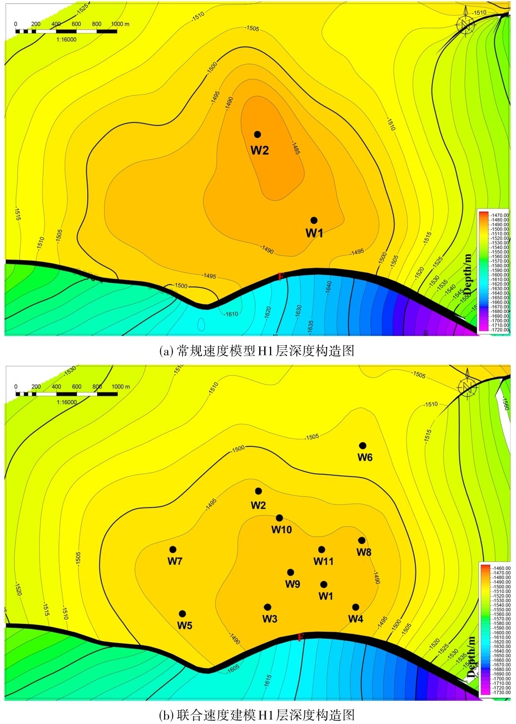
研究工区地震采集电缆长度为5400 m,目的层埋深区间1000~2500 m,满足FWI对低频有效信号、大偏移距的核心收敛要求。但在断层发育、速度横向突变的区域,全波形反演基于连续介质假设与全局迭代特性,天然对断层速度突变区适应性较差。而断控层析反演的核心价值是通过断层边界约束打破连续插值限制,精准还原断裂带速度突变特征,恰好弥补FWI的技术短板,准确还原断层区域的速度突变特征。
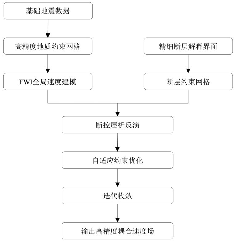
基于两类技术的互补性,本文建立全波形反演与断控层析约束相结合的联合速度建模技术思路(图3):①以原始地震道集、层位解释数据为基础,依托全波形反演完成全局迭代收敛,输出高分辨率三维速度场,作为断控层析反演的初始先验模型,替代常规均质层速度模型,保证背景速度场精度;②将收敛后的FWI速度模型导入断控层析反演系统,结合工区精细断层解释成果,人工拾取、界定各级断层边界,构建断层约束网格,对断层两侧速度场进行分区独立约束迭代,修正断层发育区的速度畸变与迭代偏差;③引入自适应阻尼系数与残差阈值约束,阻断FWI全局微弱残差向层析反演传递,规避多级迭代累积误差;持续迭代直至走时均方根残差趋于稳定,最终输出高精度耦合速度场。
图3 全波形反演和断控约束速度联合建模流程图Fig.3 Flowchart of joint modeling with full waveform inversion and fault-constrained velocity
2.1 全波形反演速度建模技术
全波形反演(Full Wave Inversion, FWI)是目前速度场反演技术中精度最高的。该技术依托梯度类局部优化算法,不断缩小正演模拟数据与原始实测地震数据的误差阈值,迭代收敛后即可输出精准的地下介质速度场。地震正演是依托已知地下介质参数推演地震响应数据的过程,反之,基于实测地震数据反推地下介质构造与物性参数的运算过程即为地震反演。因此,正演运算过程可表示为公式(1):
d=G(m)(1)
式(1)中各参数定义如下:d代表正演模拟的地震数据;G为用于描述地下介质模型与地震波传播特征之间的映射关系的正演算子;地下介质模型m涵盖速度、密度、弹性参数等多项地质参数,本次研究聚焦速度参数优化,暂不考量其余物性参数。对应的反演运算则通过逆算子实现地震数据到地下介质模型的反向推演:
m=G-1(d)(2)
式(2)中为G-1为对应G的逆算子,用于实现从地震数据到地下介质模型的反向映射。
全波形反演单次迭代流程包含两次正演运算与一次反演运算,分别为初始参数场正向波场传播、残差波场反向传播,以及波场数据分析与模型更新。从算法稳定性层面分析,若固定地震采集数据可输出唯一介质模型,且数据误差与模型误差一一对应,则反演算法具备稳定性;反之则为非稳定反演。全波形反演属于典型的高非线性、非稳定反演算法,同一组地震数据可迭代生成多个局部最优模型,只有持续迭代收敛,才能无限趋近地下真实地质模型,获取全局最优解。
全波形反演(FWI)属于典型的高非线性非稳定反演方法,其核心特征是反演解的非唯一性。同一组地震数据往往能反演出多个不同的地下介质模型,这些模型均对应FWI反演问题的局部最优解,而地下地质体真实的介质分布形态,才是该反演问题的全局最优解,也是FWI迭代优化的最终目标方向。
影响FWI效果的主要因素包括原始数据质量、子波的准确性、初始速度的准确性和炮检距的选取。结合本区的资料特等,本文采用FWI的回转波全波形反演:①低频噪声衰减,重点提高低频回转波的信噪比,同时避免了伤害有效信号;②子波估算,使用实际采集的原场子波作为FWI输入子波,提高初始子波的准确性,使正演数据和真实数据的误差求取更准确,能有效提高FWI速度反演精度与反演迭代效率;③利用初至层析反演速度模型进行近海底速度建模,提高初始速度场的准确性,更好地避免了跳周现象,使目标函数的收敛方向更准确,收敛速度更快。
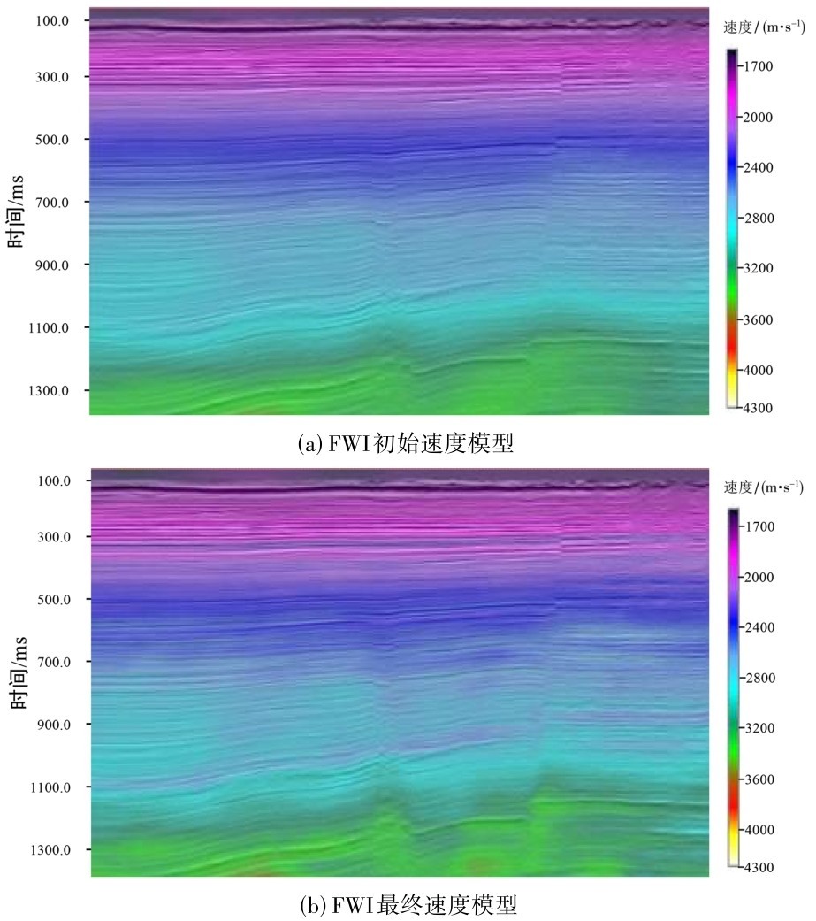
从图4 FWI初始速度场和最终速度场对比可以看出,初始模型整体偏平滑,对速度横向变化刻画不足,细节信息少,分辨率低。经全波形反演迭代优化后,最终速度场分辨率显著提升,横向速度的变化明显,更贴合地下真实地质规律,有效提升了成像精度与地质可靠性。
图4 FWI初始速度场与最终速度场的对比Fig.4 Comparison between the initial velocity field and the final velocity field of FWI
2.2 断控层析速度建模技术
断层阴影问题的本质是断层两侧速度差异引起导致。传统速度建模方法难以精准刻画断裂带速度突变特征、地层错断关系以及速度场空间非均质性,成像精度受限。针对该技术短板,本文采用的断控层析速度建模技术以断裂几何先验约束为核心,融合地震走时信息、测井数据及地质解释成果,约束断层两侧速度场独立演化以匹配实际地质规律,通过层析反演迭代修正层速度与断层速度异常,实现速度场与构造形态的准确耦合。
断控速度建模将断层曲面作为速度场间断边界,构建带断层约束的层析反演目标函数,兼顾走时残差拟合与构造正则化约束,本次断控层析反演采用约束阻尼最小二乘迭代算法,表达式如下:
式(3)中:L为地震走时正演算子;v为待反演层速度矢量;d为实际地震拾取走时;δ1为光滑正则化系数,抑制速度场过度畸变;δ2为断层构造约束权重系数;C(v)为断层边界间断约束算子,可实现断层上下盘速度场解耦更新;vprior为全波形反演获得的速度模型。
具体实现流程如下:①结合测井速度与地震走时数据,将全波形反演构建得速度作为初始背景速度场;②依据网格模型开展射线追踪正演计算,统计模拟走时与实际拾取走时的残差;③将断层几何约束算子嵌入迭代方程,对走时残差进行反向投影,分层分区更新上下盘速度参数;④引入阻尼系数抑制迭代发散,完成单次模型更新;⑤循环迭代并持续缩减走时均方根残差,直至残差降幅小于预设阈值、模型趋于收敛,终止迭代并输出最终速度场。
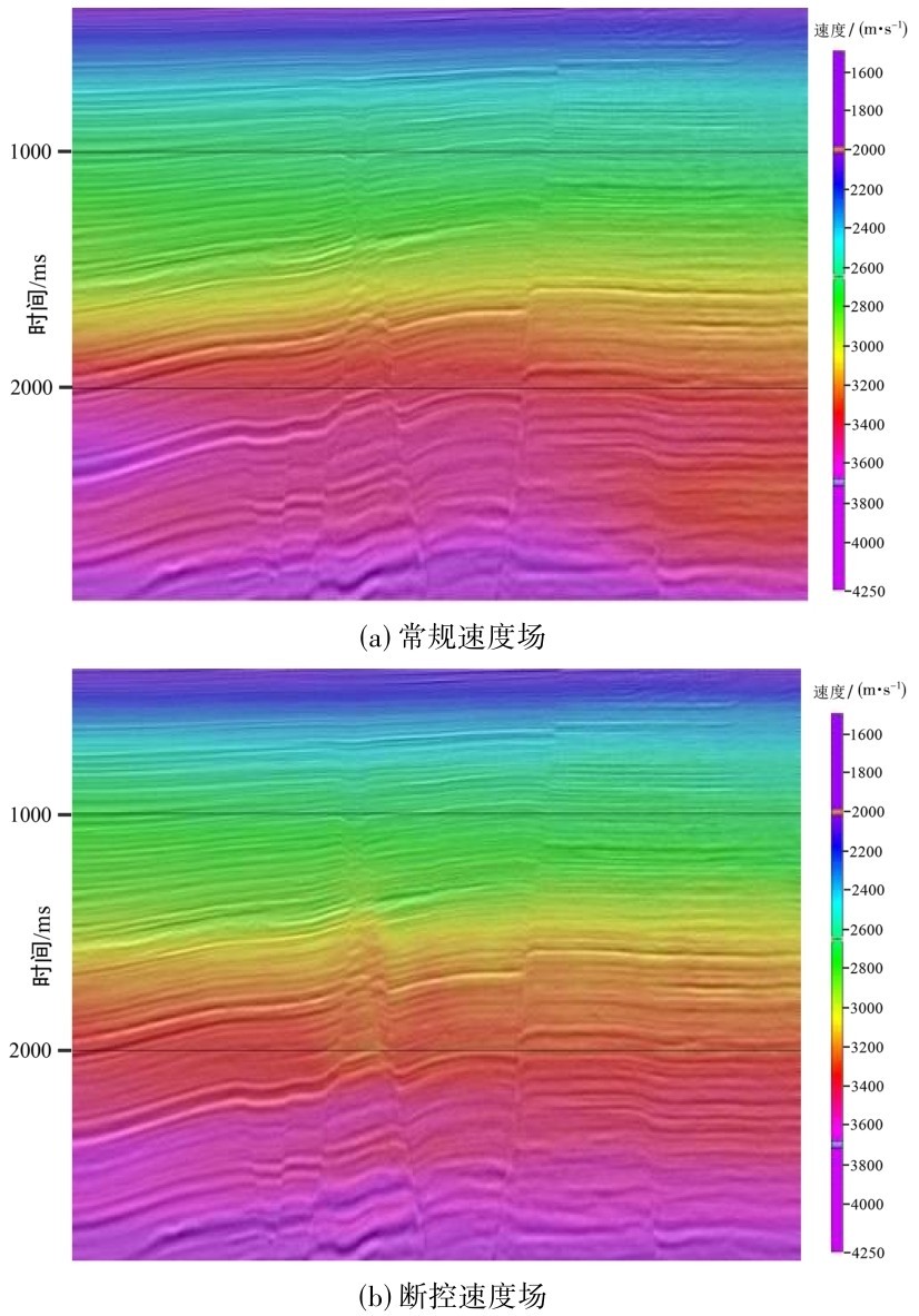
通过对比图5速度场可知,常规速度建模未融入断层边界约束,断层两侧速度场分布呈现均一化趋势,无法精准刻画出断层两侧速度异常,出现速度突变特征模糊,导致成像出现明显速度失真,难以匹配实际地质速度规律。与传统网格层析相比,图5b展示的断控网格层析方法更注重层位与断层之间的错断关系。该方法在反演过程中加入了专门针对断层的约束项,并以断层为边界,将被断层穿过的求解网格拆解为两个区域分别进行速度更新,更好的刻画和保留断层两侧速度突变特征,使得速度场分布与实际地质速度规律更吻合。
图5 常规速度场与断控速度场对比Fig.5 The comparison between the conventional velocity field and the fault-constrained velocity field