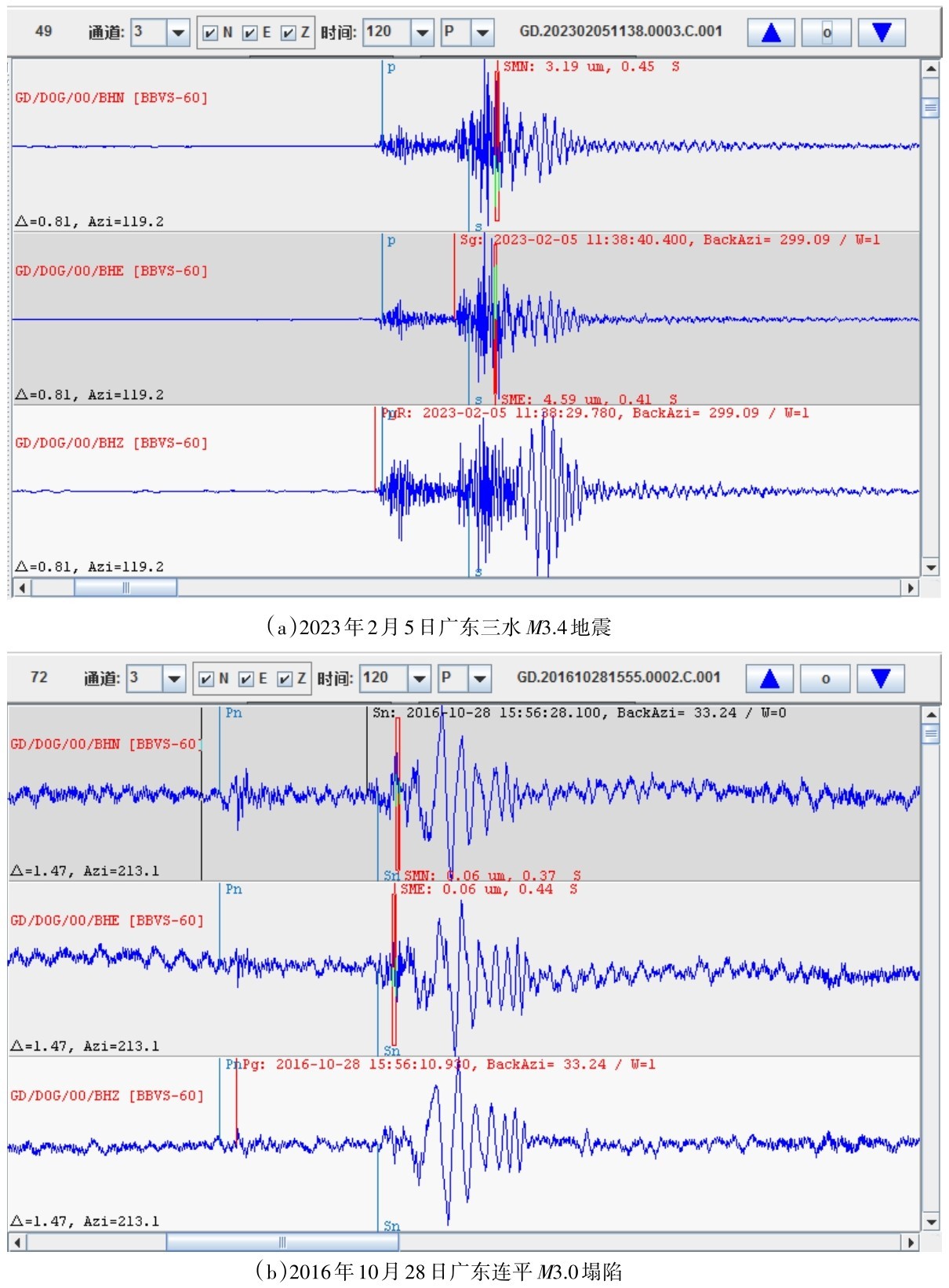
(1)1997年9月23日和26日隔坑村附近曾分别发生了ML3.3和ML4.4的地震,李纯清等人分析认为其震相特征与一般构造地震不同[28],廖华康认为这两次三水地震,不可能是天然地震,极有可能是一场塌陷地震[29]。之后该区域的地震类型一直存在争议。直至本次地震发生后,利用近年来新建的密集观测站网收集到了丰富的波形资料,综合分析判断排除此次事件为塌陷、滑坡或爆破的可能。比较两次ML4以上地震在XNH、 ZHQ和HUD三台的记录,发现相似度较高,相关系数分别是0.90、0.89和0.73,它们应该是同类型地震。
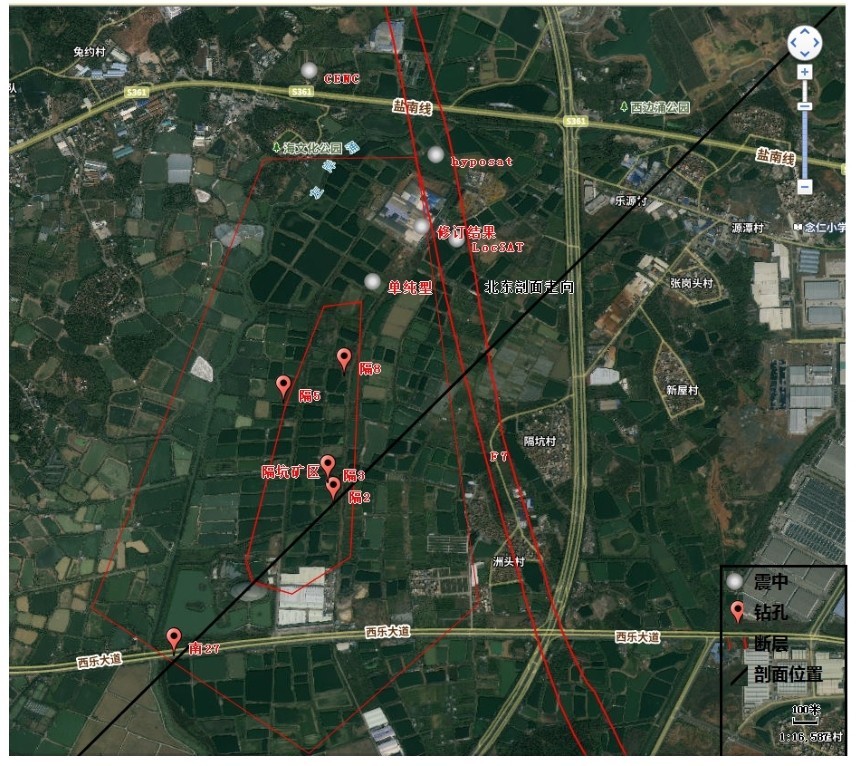
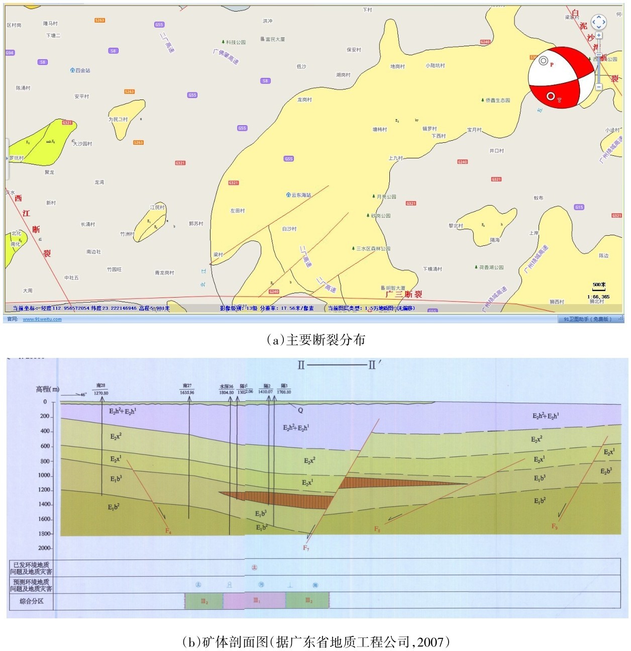
图9 三水ML4级地震震中附近的主要断裂分布Fig.9 Distribution of main faults near the epicenter of the Sanshui ML4 earthquake
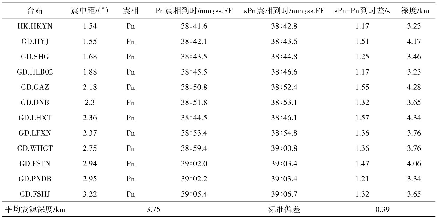
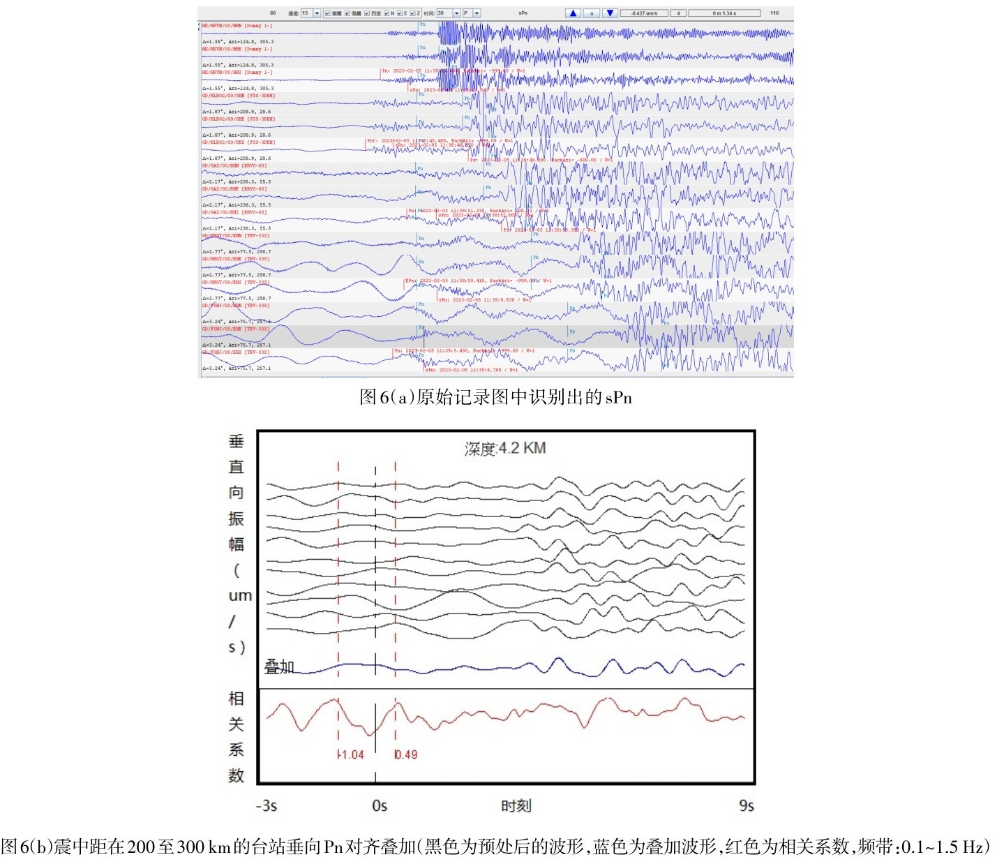
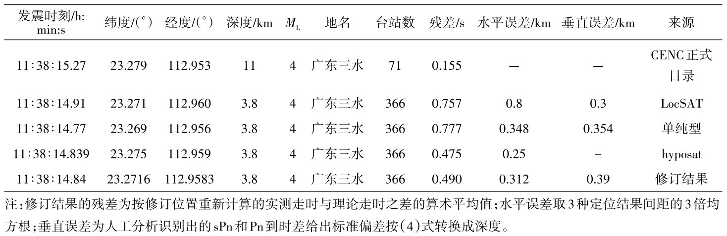
(2)依据Sn与Sg走时曲线交点对应的震中距较大、近台视出射角以及较远台记录的sPn与Pn的走时差变化等震相特征,修订了2023年2月5日广东三水ML4.0级地震的发震时刻和震源位置为:11∶38∶14.84,经度112.958°N,纬度23.270°E,深度3.8 km,震级ML4.0。震中位于隔坑盐矿矿区北东边缘与F7断层交汇处,由深度震相确定的深度比采盐井深1 km左右,距最近的隔4号开采井水平距离约500 m。从空间范围上可以确定地震发在开采区,这是典型的与采矿活动密切相关的矿山地震[27]。
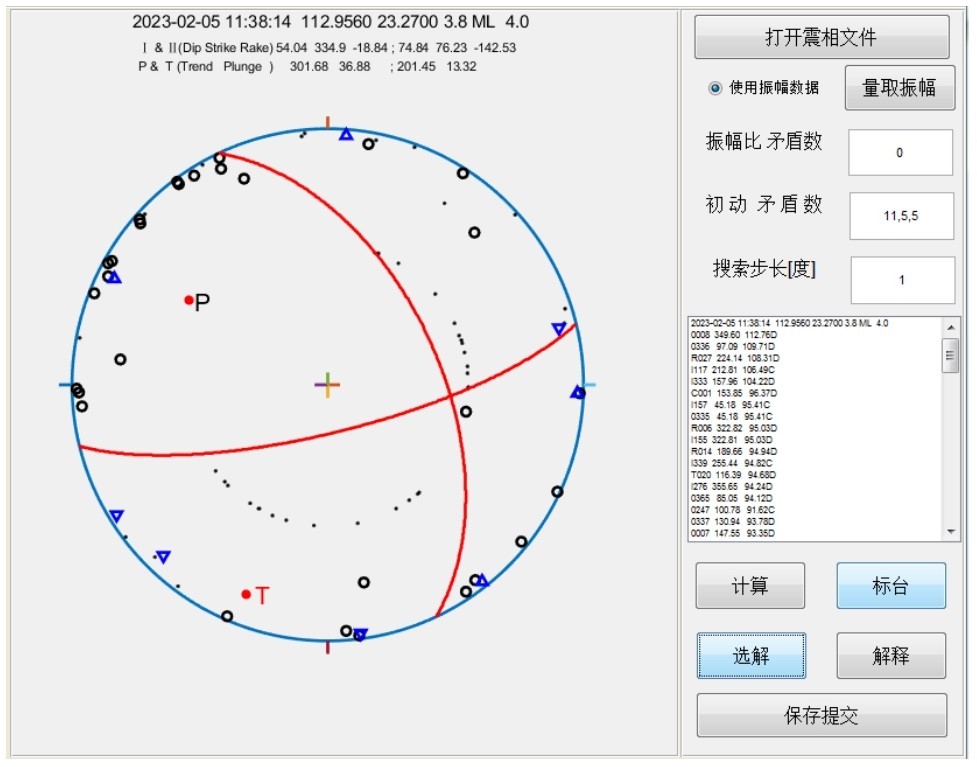
(3)结合震源机制和已探明的小区域地质构造资料,推断这次地震的发震构造走向为334.90°,倾角为54.04°,滑动角为-18.84°,可能是F7断层沿断层面发生左旋走滑正断错动而引发的。长期的抽取卤水采盐,采空区应力变化引起矿体的应力分布会发生调整,沿F7断层的应力超过了其承载能力,就使上盘发生破裂和滑动,从而引发地震。魏柏林等人研究1997年9月2次三水地震认为地震的最大主压应力轴近于直立,与重力方向一致,产生的是塌陷地震[30]。我们研究结果似乎不全支持其结论,虽然都是沿F7断层滑动,但最大主压应力轴并非与重力方向一致,而是与该区域的主压力σ1较一致,即是区域应力主控制下的矿体应力调整。重力主导下矿区应力调整产生的矿震应该多数是孤立的,与周边的中强震时空关系不明显,但区域应力场控制下的调整则会与周边的中强震存在某种看似巧合的时空关系。
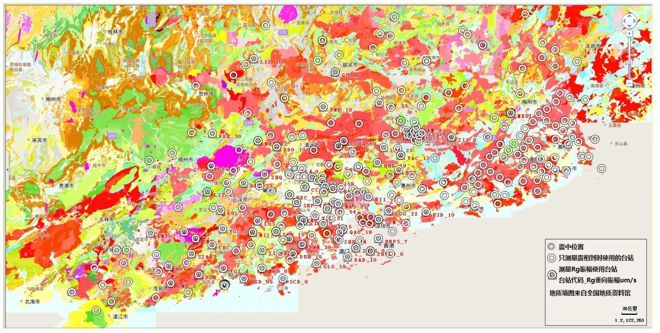
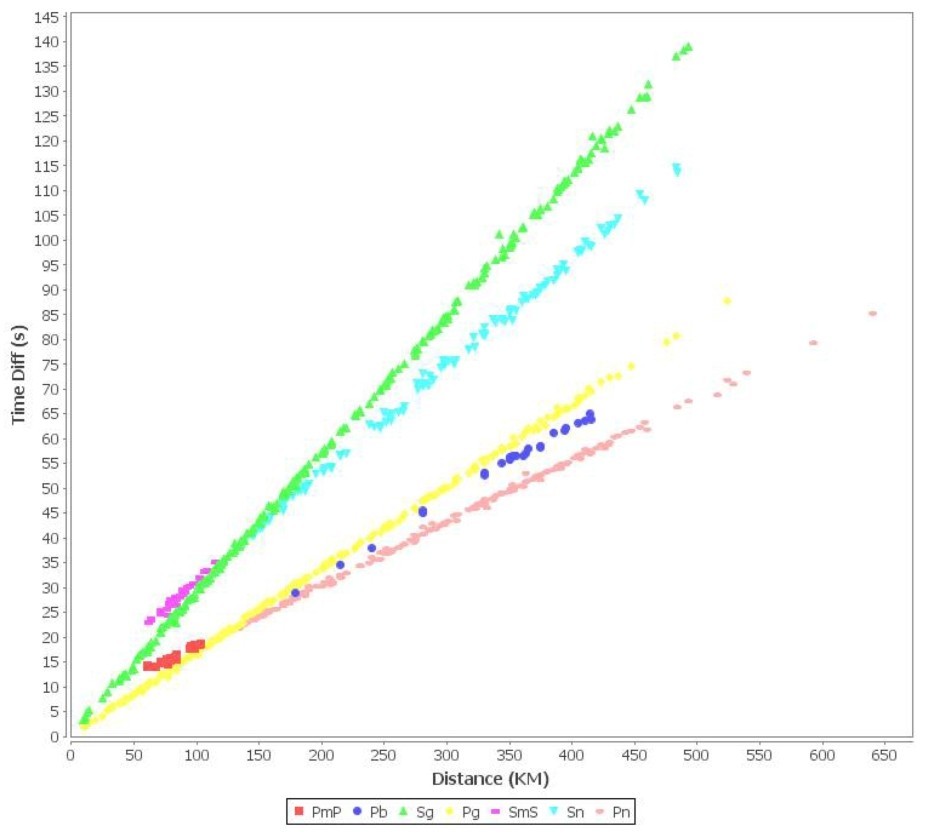
(4)深度为3.8 km是一次罕见的浅源地震。据广州市地震活断层探测与地震危险性评价时深反射地震勘探专题报告给出白坭—沙湾断裂附近的剖面浅部(4 km以上)成层性较好,层位较多,地层结构简单,总体趋势为西高东低的单斜形态,岩性可能是沉积岩层。震源在沉积层产生的P波与SV波大于临界角入射,由P波与SV波耦合在自由地表形成的波动即为短周期的瑞利面波Rg,从观测点的空间分布看Rg波的发育程度似乎还与震中距和台站附近的沉积层厚度相关。本文初步分析广东地区Rg波的最大峰值的视速度(周期在1.1~1.5 s间近似的群速度)约为2.85 km/s,峰值振幅随震中距的衰减关系为: log(Vmax)=-1.8004*log (Δ)+5.0812。从三水地区的震例研究认为极浅源地震激发的Rg波是造成震级小、震中烈度高、破坏性大和选择性破坏明显为其特征[21]的主要因素,在采矿区附近或有定沉积层建设场地的抗震设防工作中应该给予足够的重视。
附2023年2月5日三水ML4.0级地震获取广东地区Rg波初步特征
图1)广东三水地震的Rg波峰值速度对应走时随震中距变化Fig.1 Variation of travel time corresponding to peak velocity of Rg wave with epicentral distance of Sanshui earthquake,Guangdong">

图1)广东三水地震的Rg波峰值速度对应走时随震中距变化Fig.1 Variation of travel time corresponding to peak velocity of Rg wave with epicentral distance of Sanshui earthquake,Guangdong"/>
图1)广东三水地震的Rg波峰值速度对应走时随震中距变化
Fig.1 Variation of travel time corresponding to peak velocity of Rg wave with epicentral distance of Sanshui earthquake,Guangdong">图 10 (附图1)广东三水地震的Rg波峰值速度对应走时随震中距变化Fig.1 Variation of travel time corresponding to peak velocity of Rg wave with epicentral distance of Sanshui earthquake,Guangdong
图2)广东三水地震的Rg波垂向最大振幅随震中距变化Fig.2 The variation of vertical maximum amplitude of Rg wave with epicentral distance in Sanshui earthquake,Guangdong">

图2)广东三水地震的Rg波垂向最大振幅随震中距变化Fig.2 The variation of vertical maximum amplitude of Rg wave with epicentral distance in Sanshui earthquake,Guangdong"/>
图2)广东三水地震的Rg波垂向最大振幅随震中距变化
Fig.2 The variation of vertical maximum amplitude of Rg wave with epicentral distance in Sanshui earthquake,Guangdong">图 11 (附图2)广东三水地震的Rg波垂向最大振幅随震中距变化Fig.2 The variation of vertical maximum amplitude of Rg wave with epicentral distance in Sanshui earthquake,Guangdong