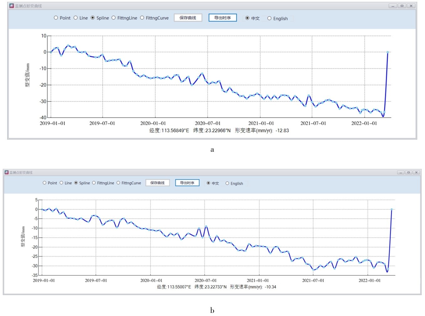
黄埔区位于广州市东部,与白云、天河、海珠、增城和从化交界,总面积约484平方千米。区内古生界变质岩台地低丘地貌,主要由石英岩、片麻岩、斜长片麻岩等组成,分布在长洲岛。第三系中新统红色砂岩主要分布于南侧平原中,主要由凝灰质砾岩、砂岩、页岩组成。第四系冲积层分布于广深公路南侧及沙洲上,主要砂砾、砾石、砂质壤土等组成。地貌类型多样,叠加汛期强降雨和人类工程活动等影响引发崩塌、滑坡、泥石流斜坡变形为主。
1.1 雷达数据预处理
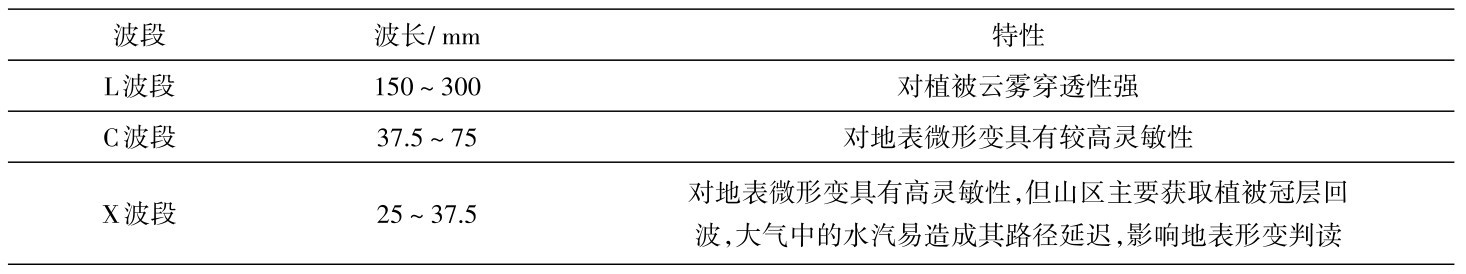
星载雷达数据是大范围获取地表形变主要数据源,其成像模式、分辨率、时间基线等参数对监测结果具有较大影响。L波数据穿透植被能力较强,适合用于多植被覆盖区;C波数据具备一定植被穿透能力,可以作为L波数据的补充;X波数据对地表微形变具有高灵敏性,可实现地表微小形变的监测,但植被区失相干较为明显[17],如表1所示。
表1 星载合成孔径干涉雷达参数及特性Table 1 Parameters and characteristics of spaceborne InSAR
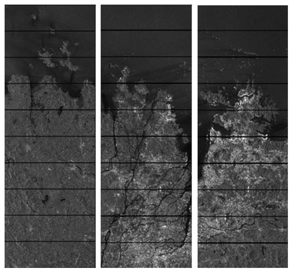
本文主要采用欧空局免费发布的C波Sentinel-1A VH极化升轨数据,IW模式采用TOPS(Terrain Observation with Progressive Scans in azimuth)技术,一景SAR影像可以成像三个子条带及多个Burst,如图1所示,并根据研究区范围进行裁剪拼接,形成整幅单视复数影像。精密轨道数据来源于Sentinel-1A官方AUX_POEORB精确的轨道星历参数。Sentinel-1A使用精密轨道控制技术,以保证干涉对的空间基线在100 m范围内,采用成像21天之后发布的POD精轨数据,定位精度5 cm以内。
图1 IW成像模式形成的子条带及Burst Fig.1 Sub-bands and Burst formed by IW imaging mode
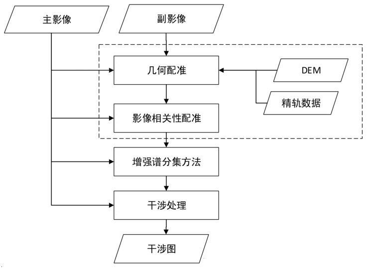
图2 雷达影像干涉处理流程Fig.2 Interference processing flow of radar images
数字高程模型DEM数据采用分辨率相对较高免费发布的AW3D30成果。对其中范围内部分无效数值区先进行探测,根据Kriging插值方法进行修正补充,对预处理后的DEM数据进行拼接及地理编码,统一到SAR影像统一坐标系。采用粗配准和精配准联合的方式处理,以消除多普勒质心偏移,以及由轨道不平行引起的系统误差及TOPS模式方位向特殊性的问题,干涉处理方法如图2所示。使用增强谱分集(ESD)方法进行高精度配准时,需要进行相位解缠,得到的解缠差分相位为[-π, π ],相当于Sentinel-1A0.05个像元,因此粗配准精度应达到0.05个像元。
1.2 SBAS-InSAR小基线集时序干涉测量
小基线集方法(SBAS-InSAR)通过选取多主影像干涉,更好削弱由于时间基线过程而导致的时间失相干[18]。假设共有N景影像,组成的小基线集含有M个干涉对,ϕT为各时间点上SAR影像中高相干点对应的相位(相对于参考点)组成的向量,即待求参数可表示为式(1):
ϕT=[ϕ( t 1 ),…,ϕ( tN ) ](1)
δϕT表示多时相干涉图解缠后相位组成的向量,δϕi为观测量,即:
δϕT =[ δϕ1,…,δϕM](2)
主影像(IE)和从影像(IS)对应的时间序列分别为:
IE=[IE1,…,IEM ] IS=[IS1,…,ISM ](3)
假设主从影像是按照时间顺序排列的,即IEj>ISj,其中j=1,…,M ,则第j幅干涉图对应的相位可表示为:
δϕj=ϕ( tIEj ) -ϕ( tISj ) , j=1 ,…, M (4)
对于所有干涉图,将式(4)的线性模型表示为矩阵形式:
δϕ=Aϕ (5)
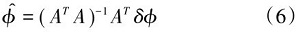
其中,系数矩阵A[M×N]每一行对应于一个干涉图,每一列对应于一景SAR图像。对于式(5),有M个方程,N个未知量。如果M≥N,且A的秩是N,则利用最小二乘法可得:
当矩阵A的秩小于N时,相应的法方程系数阵ATA秩亏,因而根据最小二乘法得到的解不唯一。为解决系数阵关联和不同基线集之间的连接引起的法方程秩亏,采用奇异值分解(SVD)方法求解。
式(7)即为第j幅干涉图的相位值等于各时段速度在主从影像时间间隔上的积分,将其写成矩阵形式,即可得到一个新的矩阵方程:
δϕ=Bv(8)
和式(5)的矩阵A一样,B也是一个M×N矩阵。对第j行,位于主辅图像获取时间之间的列B(j,k)=tk+1-tk ,否则B(j, k)=0。将SVD分解应用于矩阵B,就可以得到速度矢量v的最小范数解。根据各个时间区间的沉降速度,对各时段速度在时间域上进行积分即可得到各个时间段的形变量。通过引入不同的线性相位贡献参数(DEM引起的误差,轨道误差等),可精确地估计各参数,使形变估计更准确。在线性模型的基础上,继续通过对残余相位进行时空滤波分离出大气相位和非线性形变相位,利用式(9)形变相位转换将地表形变相位场转换为形变距离场。