2.1 剖面层序的基本特征
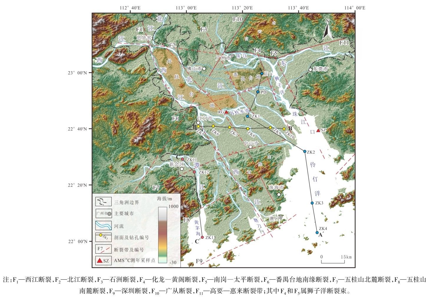
在海量钻孔的分析及与标准钻孔(含已发表的钻孔、科研钻孔、本次研究的钻孔等)对比的基础上,编制了珠江三角洲北北西—南南东(A-A′剖面)、近东西向(B-B′剖面)以及近南北向(C-C′剖面)等三条综合剖面图(图4~图6)。
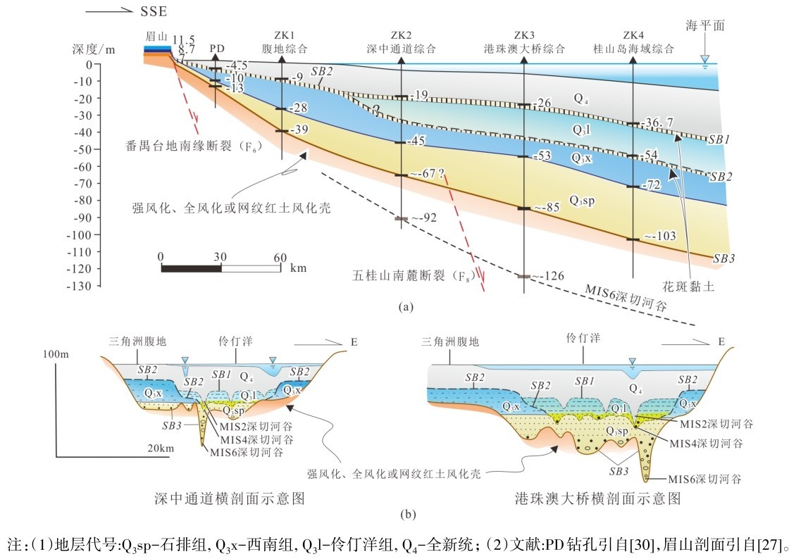
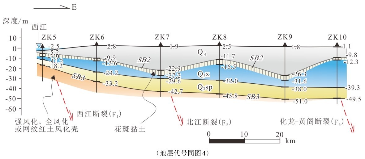
A-A′剖面(北北西—南南东钻孔综合剖面图,图3,4a)显示,从三角洲腹地到珠江口地区,西南组顶部花斑黏土(SB2)分布广,埋藏浅,连续性好;而在珠江口—伶仃洋一带,花斑黏土(SB2)埋深较大(一般-40 m~-46 m),分布局限(图4a),说明西南组上部先侵蚀后风化的过程;基底岩石风化壳(SB3)分布广,厚度大(一般>10 m),埋深从三角洲北部的-13 m(PD)逐渐过渡到三角洲腹地的-39 m(腹地综合钻孔,ZK1),然后增大到珠江口(深中通道综合钻孔,ZK2)约-67 m和伶仃洋(港珠澳大桥综合钻孔,ZK3)-85 m左右。
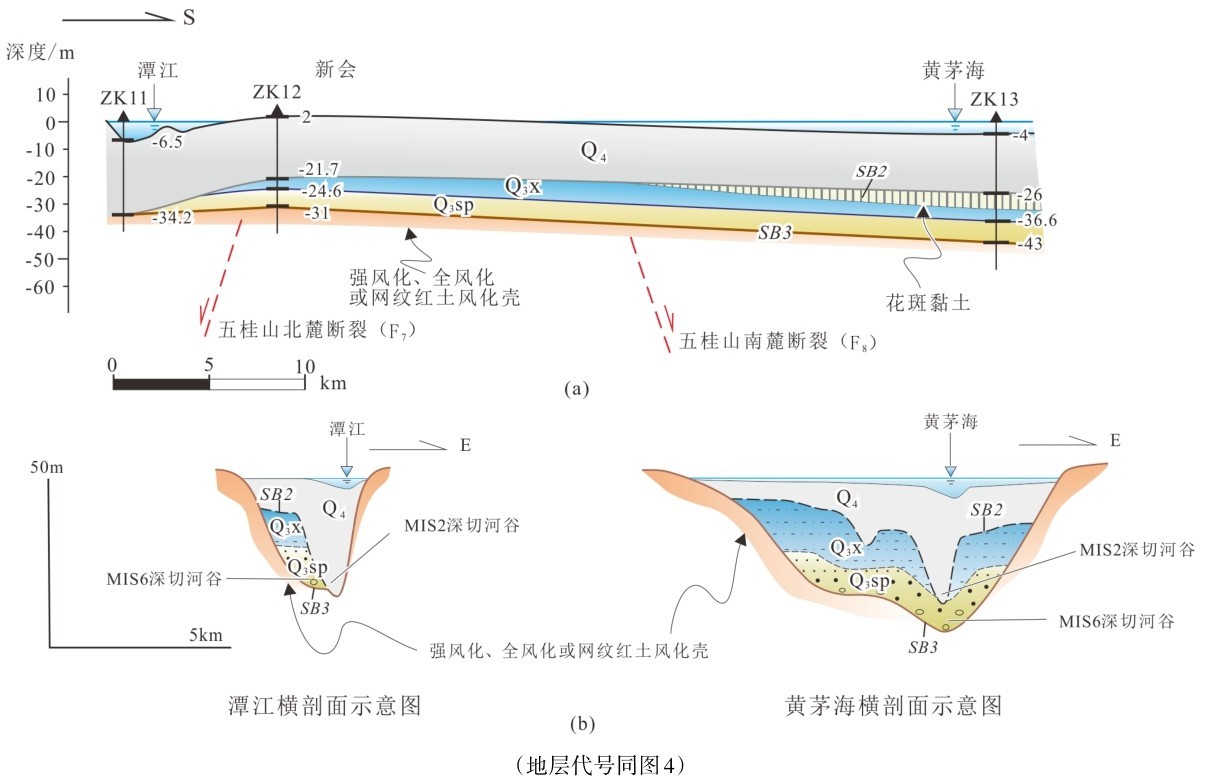
与纵剖面垂直的深中通道、港珠澳大桥两条横剖面(图4b)显示,石排组和西南组成上叠关系,而伶仃洋组和“西南组+石排组”成内叠关系,两者均被全新统所掩埋,构成“上叠+内叠+埋藏”的复杂沉积组合。SB1、SB2和SB3三条层序边界均形成于冰期低海面时的下切侵蚀时期,各自都表现出深切河谷的轮廓(图4b)。
图3 珠江三角洲地貌与断裂分布Fig.3 Topography and faults distribution in the Pearl River Delta
图4 珠江三角洲A-A′钻孔综合剖面Fig.4 The A-A’comprehensive stratigraphic profile of the Pearl River Delta
冰期时,三角洲向南海北部大陆架方向推进,珠江三角洲内部以下蚀为主,东江、北江和西江等三大河流均为“过路河”(by-pass river),河流切入早期沉积物或基岩风化壳之中,形成层序边界。SB3的下切深度从港珠澳大桥一带的-126 m左右向源逐渐上升到深中通道附近的-92 m左右(图4a),清楚地显示下切侵蚀和溯源侵蚀过程。如果三条层序边界代表冰期低海面的侵蚀,那么三角洲内的各组地层则主要是间冰期海面上升时的堆积。
实际上,前人也报道过珠江口一带发现两层花斑黏土,特征和埋深与本文的描述相似,并认为上层形成于MIS2,下层形成于MIS3[31],但并未明确两层花斑黏土的叠置关系。现已查明,珠江口—伶仃洋一带的上层花斑黏土相当于SB1,形成于MIS2;而下层花斑黏土相当于SB2,形成于MIS4(图4b),由于经受过侵蚀,下层花斑黏土发育程度不如上层。
B-B′剖面(近东西向钻孔综合剖面,图3,5):与A-A′剖面类似,西南组顶部花斑黏土(SB2)分布广,一般埋深-10 m左右,最大可达-23~-26 m,界面略呈波状起伏,反映西南组沉积后,经历了河流的侧蚀和下蚀,再经受风化。基底基岩风化强烈,从西向东风化壳保留渐差,并逐渐消失,暗示河流向东侧蚀和下蚀加强,基岩风化壳几乎剥蚀殆尽;与此同时,基岩埋深也从-18 m左右向东逐渐加深到-50 m多,构成向东缓倾斜的SB3。该剖面缺少SB1。
图5 珠江三角洲B-B′钻孔综合剖面Fig.5 The B-B’comprehensive stratigraphic profile of the Pearl River Delta
C-C′剖面(近南北向钻孔综合剖面,图3,6a)沿潭江从新会七堡大桥河段(ZK11)到黄茅海(ZK13),基底基岩风化也十分强烈(SB3),埋深大致在-31 m~-40 m之间,深度是珠江口-伶仃洋河口地区的1/2左右;石排组沉积前(SB3)和西南组沉积后(SB2)的下切侵蚀和溯源侵蚀的下切清晰可见(图6b),尤其是后者更加明显;西南组保留不好,残留厚度较小(0 m~14 m),但全新统厚度却与珠江三角洲腹地等量齐观,在新会七堡大桥河段,个别钻孔仅见全新世淤泥,西南组连同石排组一道几乎都被侵蚀殆尽。这可能与潭江大体上为基岩河道 有 关(剥 蚀 限 制 河 道, detachment-limited channel,河流以侵蚀作用为主[32]),由于河流受限于基岩,难以自由摆动,西南组沉积后的下切侵蚀和溯源侵蚀尤为明显。下游河口地区的黄茅海与上游新会地区的七堡大桥河段下切侵蚀幅度相近,暗示冰期造成的下切侵蚀和溯源侵蚀已经深入到内陆,远离河口。
2.2 地层时代讨论
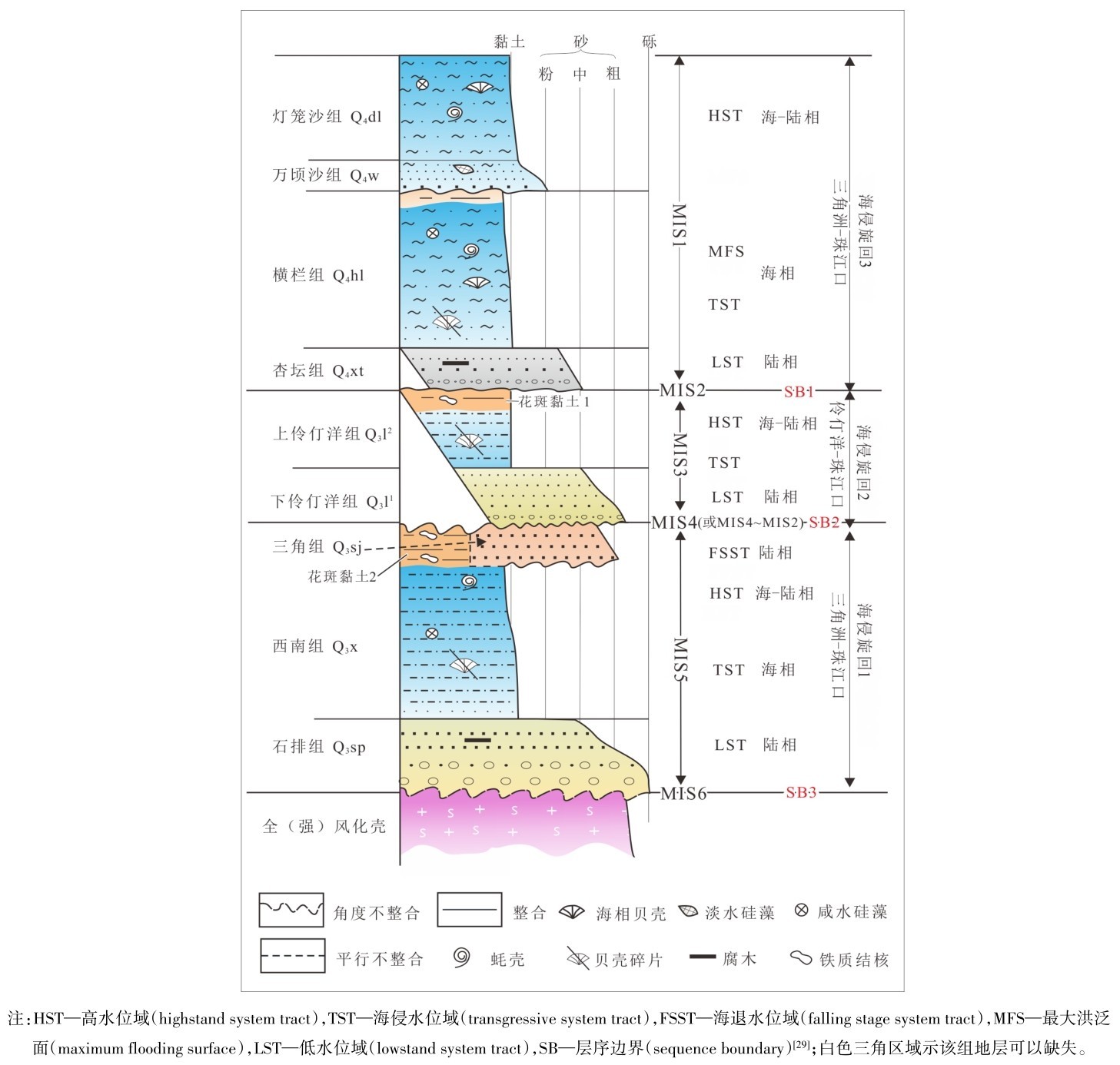
SB1、SB2和SB3等3条层序边界把珠江三角洲沉积划分出3个海侵-海退旋回(图1),这些层序边界形成于冰期低海面,边界之间则为间冰期海侵堆积。如果SB1、 SB2和SB3分别归于MIS2, MIS4 (或MIS4~2)和MIS6,有理由认为,上更新统下部的石排组和西南组相当于MIS5时期的沉积,结合光释光年龄结果[14,26,27]和埋深(通常位于-10~-40 m之间),更佐证了MIS5时期的认识;上更新统上部的伶仃洋组相当于MIS3时期的沉积;全新统则全为MIS1时期的沉积。珠江口-伶仃洋地区3条层序边界发育完整, SB1和SB2花斑黏土发育均较弱;三角洲腹地普遍缺失SB1(缺少MIS4~2的沉积),因风化时间更长,花斑黏土发育更好、更典型。此外,SB3风化长而强,是热带-亚热带准平原化的产物,已经发育成网纹红土风化壳[33]。对珠江三角洲地层的划分和对应时代如图1、4、5和6所示。
图6 珠江三角洲C-C′钻孔综合剖面图Fig.6 The C-C’comprehensive stratigraphic profile of the Pearl River Delta
2.3 珠江三角洲构造下沉时间及下沉速率
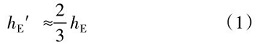
假设全球性海平面变化(eustatic sea level changes,水动型海平面变化)的升降幅度为hE,由于水均衡作用,稳定大陆沿海实际观察到的海平面变化为hE′,假定地幔密度为3 g/cm3,理论上有[34]:
由于地球上不同地方地幔黏度不同,均衡响应时间各异,响应幅度也会有很大差别,hE′ 很可能大于 E。根据前人[35]对东亚地区地球动力学模拟研究结果,可设:
hE′ ≈0.9hE(2)
假设地动型海平面变化(tectonic sea level changes)为hT,那么实际观察到的海平面变化(海平面变化留下的遗迹,sea level changes)为hS,有:
hS=hE′ +hT(3)
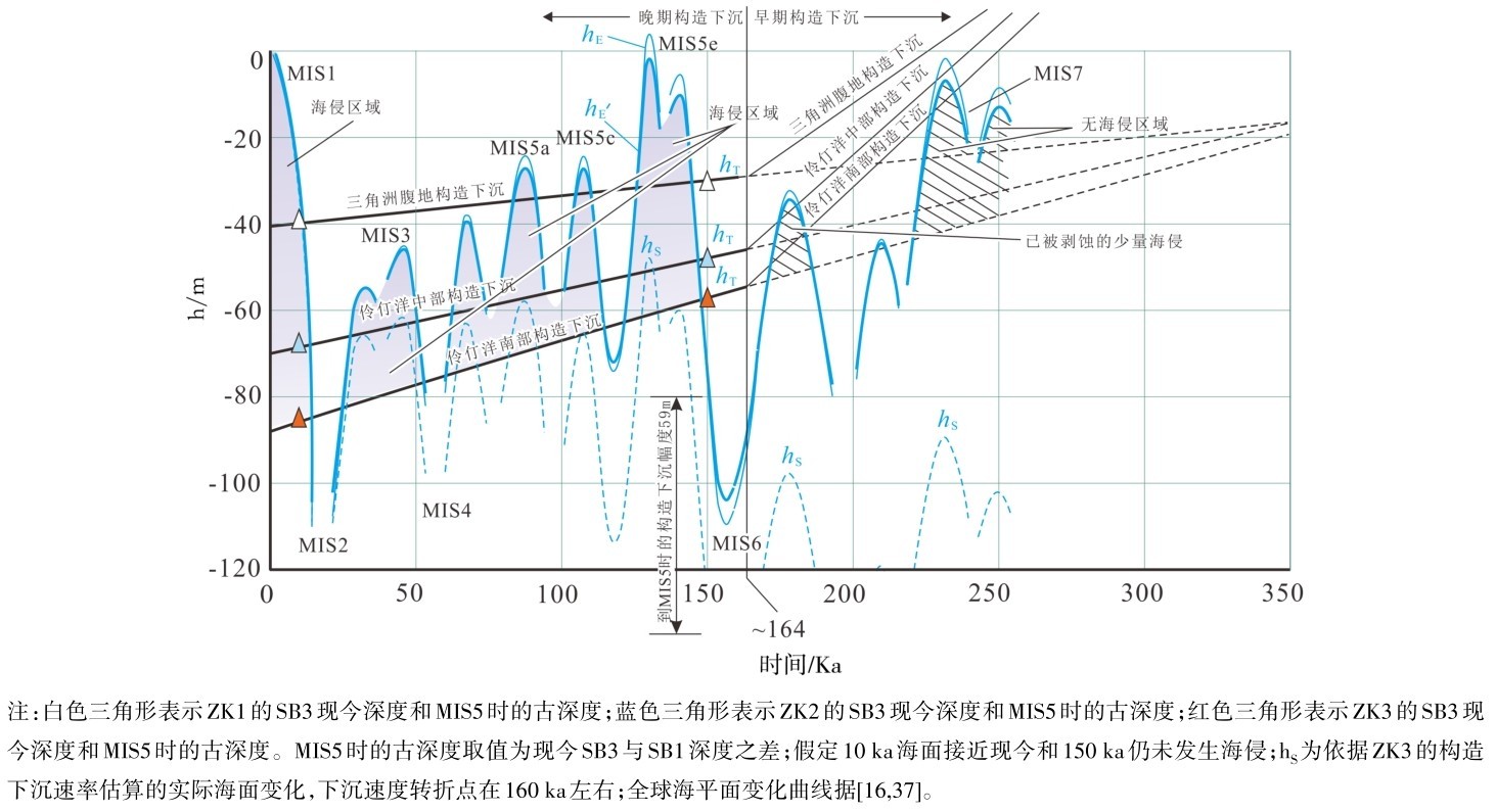
hS、hE、hE′ 和hT分别用虚曲线、细曲线、粗曲线和直线表示(图7)。构造升降周期远大于冰期-间冰期海面变动周期[36],因此,水动型海面变化表现为曲线,而地动型海平面变化则近似地为直线。
图7中清楚地显示,MIS5以来的高海面均可影响到伶仃洋地区(图中淡紫色阴影区),即在MIS5和MIS3都可以发生海侵;然而,对三角洲腹地而言,仅可能发生MIS5海侵,MIS3时期的高海面不可溯及。图中清楚地印证了上述对三角洲地层时代的分析。
由于三角洲广大地区缺失早于MIS5的第四纪沉积(图中斜线区),构造下沉何时开始尚不得而知。比较合理的解释是,三角洲地区于MIS7(约250 ka)已下沉至现今海平面附近,由于MIS7高海面略低于MIS1,三角洲广大地区依然难以发生广泛海侵(伶仃洋等局部埋藏峡谷地区海侵可能早些)(图7);尽管MIS6时可以下沉至现今海平面以下,然而适逢冰期低海面,三角洲地区仍然处于下切侵蚀状态,形成SB3;MIS7基本上无海侵,而MIS5发生广泛海侵,两期深海氧同位素阶段很好地限制了研究区下沉到现今海面附近的起始时间。
假如三角洲地区构造下沉分早、晚两期:早期于250 ka前后下沉到现在海平面附近,下沉速率最大值≤0.6 mm/a,速率较快;晚期大约从160 ka至现今,下沉速率减缓,下沉速率最大值约为0.16 mm/a;若从250 ka至今,平均下沉速率约为0.34 mm/a。由于MIS5海面高于MIS1海面约5~7 m,但分布沉积范围却小于MIS1,暗示珠江三角洲地区冰期—间冰期造成的海平面升降变化与持续构造下沉的叠加,即内动力和外动力的耦合作用。
图7 珠江三角洲水动型和地动型海平面变化Fig.7 Hydrodynamic and geodynamic sea level changes in the Pearl River Delta
珠江三角洲地区的深切峡谷,在伶仃洋南部可到-126 m左右,在伶仃洋北部可达-90 m左右,清楚地显示了珠江主河道在冰期低海面造成的下切侵蚀和溯源侵蚀(图4)。在黄茅海深切峡谷深约-43 m,北部新会一带可达-34.2 m左右,也显示冰期低海面造成的潭江下切侵蚀和溯源侵蚀(图6)。注意到与A-A′剖面相比,潭江SB3较缓,SB2较陡,缺失SB1(图6b),而且下切深度与珠江口-伶仃洋一带无法相比(仅是珠江口—伶仃洋地区的1/2左右),暗示MIS2末次盛冰期低海面的影响远大于MIS6低海面的影响,MIS6时黄茅海构造下沉仍较弱,与现今相比距离南海更远。
深切河谷是海面下降和构造下沉联合作用造成的(即hE′ +hT)(图7),因此,不宜用峡谷最低点来估算构造下沉速率。
珠江三角洲地区,强风化带、全风化带或网纹红土带被沉积物掩埋而保存较好。前人研究表明,网纹红土的形成时间十分漫长,红土风化壳的形成时间大于1Ma,而白色的“网纹”大约经400 ka前后的淋滤作用而成[33],反映了亚热带地区准平原作用的特点,即以风化作用为主,剥蚀作用十分微弱,属于“风化限制(weather limited) ”风化壳[38],构造稳定(风化壳)到构造活化(埋藏风化壳)没有经历明显的抬升剥蚀,而直接由长期稳定转为下沉,风化壳被海侵所超覆并掩埋。由此,三角洲内部的山地的隆升时间可能更早,目前所见山地至少是在早更新世或更早时期隆起的,经历了后期风化和剥蚀,目前三角洲内部大部分地区连同山地都处于下沉状态。
2.4 珠江三角洲构造差异下沉
按基底(SB3)深度估算,北部下沉幅度较小,仅至-10 m多,到伶仃洋南部,下沉幅度达到-85 m,显示珠江三角洲东部从北往南掀斜式构造下沉的态势(图4)。无论三角洲基底(SB3)还是两层花斑黏土层(SB2、SB1)都有逐渐降低的趋势,其中基底(SB3)倾斜较大,SB1倾斜较小,反映三角洲掀斜下沉量的积累过程(图4)。
除边界断裂,综合剖面图没有显示三角洲内部断裂有明显的差异运动,不排除边界断裂晚期的活动性显著减弱,与三角洲广大地区类似,例如西江断裂[39]。
若扣除低海面深切,沿南北向的潭江(新会七堡大桥至黄茅海)构造下沉幅度大致为30 m(图6),下沉幅度南部略大于北部,依据伶仃洋的计算方法,250 ka以来平均下沉速率大致为0.15 mm/a,相当于伶仃洋的1/2;同理,可以计算成珠三角腹地东西向剖面所反映的构造下沉速率最大值为0.2 mm/a(图5)。综合A-A′、B-B′和C-C′等3个剖面(图4~图6)可以看出,三角洲的掀斜下沉幅度东大于西,南大于北,最大掀斜下沉方向大致沿北北西—南南东一线。不难理解,南北向和近东西向剖面反映的只是三角洲下沉的“视速度”,而番禺台地南—伶仃洋近北北西向剖面所反映的下沉速度最大,应该接近于“真速度”,掀斜下沉方向近似地平行于北北西向断裂走向。结合北北西断裂控制的三角洲轮廓,推测三角洲东西两侧的边界断裂早期的活动性较强,由于北东东向断裂也有一定的地貌表现,不排除北东东向断裂的活动性,尤其是番禺台地南麓断裂、五桂山南麓断裂等。
2.5 珠江三角洲的古地貌
“丹灶台地”向东南倾没于三角洲堆积平原之下,可以想象,“丹灶台地”、“番禺台地”等及其两侧的河流应该是三角洲形成之前较为普遍的古地貌景观,即在下沉之前,珠江三角洲地区是星罗棋布的低矮山地+宽阔台地+“过路河”的地貌组合,当时的海岸线与现今相比,更靠近南海。