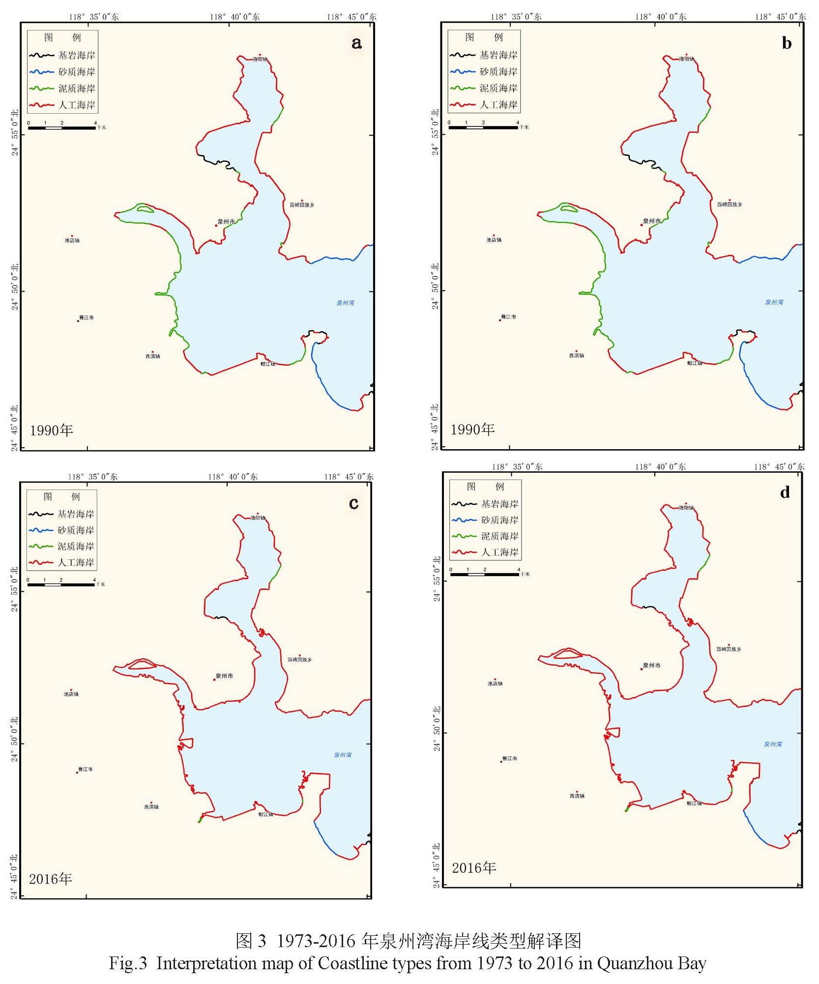
根据上述岸线遥感判别标志和分类方案,本研究分别解译了四个时相的基岩岸线、砂质岸线、泥质岸线和人工岸线。最后通过GIS 矢量线修正处理, 得到符合要求的岸线文件, 以用于ArcGIS 软件进行岸线分析处理, 其解译结果如图3所示。
图3 1973-2016年泉州湾海岸线类型解译图
Fig.3 Interpretation map of Coastline types from 1973 to 2016 in Quanzhou Bay
由图3a可以看出,1973年泉州湾区域内四种岸线均有发育,各类型岸线交叉分布在沿岸各处且各类型长度相差不大,其中以人工岸线为主,泥质岸线和基岩岸线次之 ,砂质岸线占比最少。泥质岸线主要发育于泉州湾南部锦里村、思进村及晋江入海口的溪头村、沉洲一带 ,洛阳江入海口西岸的金屿、凤屿一带和东岸西方村至曾垵村一带也有发育;基岩岸线主要发育于晋江入海口北岸和洛阳江入海口西岸北山沿线;砂质岸线主要分布在湾口最南边的大厦村及对岸的后港村沿线。
由图3b可以看出,1973—1990年研究区内主要表现为自然岸线向人工岸线转换,各类型岸线所占比例都有不同程度的变化,人工岸线迅速大幅度增加 ,基岩岸线大幅度减少 ,而泥质岸线只有较小比例的变化。在晋江入海口北岸法石至洵浦一带和洛阳江入海口西岸,因修建后渚港和港丰石化码头等人工建筑,大量砂质、泥质、基岩岸线转变为人工岸线 ,在这些区域,人工岸线大面积连接成片。区域内没有发育生物岸线。
由图3c可以看出,1990—2000年,自然岸线继续向人工岸线转换,人工岸线持续保持高速增长态势,泥质岸线大幅度减少 ,人工岸线成为绝对主导岸线类型。在西滨镇北头村一直往北至晋江入海口南岸海尾村,期间围垦养殖发展迅速,以及城市用地扩张 ,该区域内泥质岸线和基岩岸线几乎全部转变为人工岸线。至此,湾区内人工岸线全面成片连线 ,只有个别地区存在泥质岸线。生物岸线仍然未在该区域出现,砂质岸线变化较为微弱。
由图3d可以看出,到2016年,人工岸线持续增加的趋势更为明显,自然岸线长度继续下降。港口码头扩建和围垦等社会经济活动使人工岸线全面连接成片,湾内几乎全为人工岸线。基岩岸线长度上虽然仍然出现了减少 ,但是减少的幅度较以往年份有所下降。区域内没有发育生物岸线,砂质岸线仅仅在泉州湾南端的大厦村有少量发育。
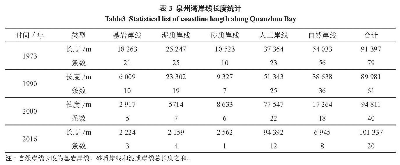
3.1 海岸线长度变化
利用ArcGIS软件计算研究区四个时相各类型岸线的长度及条带数(表3)。
表3 泉州湾岸线长度统计
Table 3 Statistical list of coastline length along Quanzhou Bay
表3的各时相岸线类型统计数据显示,岸线总体呈增长趋势。除 1973年到1990年岸线总长度略有缩减,1990年到2016年均为增长态势,43a来海岸线总长度增加了约 9940 m,其中人工岸线持续增长,自然岸线持续减少。 1973年到1990年岸线总长度减少了了1416 m,减少量约为1.5%,其中基岩岸线大幅减少了122 545 m,人工岸线增加了 13 979 m。1990年后岸线长度开始增加,到2000年岸线总长度达到了94 811 m,增加4 830 m,平均增长速率为483 m/a,基岩岸线和泥质岸线减少,尤其是泥质岸线锐减17 588 m,人工岸线增长速度加快,增长了26 204 m。2000年到2016年增加了6 526 m,增长率约为6.9%,平均增长速率约为408 m/a,自然岸线全部类型向人工岸线转换。由此可见,1990—2016年,随着福建沿海经济的高速发展,岸线的增长速度较快 ,海岸线长度增加主要是围垦养殖、港口码头扩建等人工海岸线修筑造成,该区域内有明显的人为陆地向海洋延伸现象发生。
3.2 海岸线类型结构变化
四个时相的岸线数据表明(表3),泉州湾自然岸线比例不断缩减 ,从占比 19.7%减少到6.6%,缩减幅度多达70%,自然岸线大类中的所有类型岸线均有不同程度减少,其中泥质岸线减少最大,缩减幅度超过90%,基岩岸线缩减幅度也接近90%,砂质岸线缩减幅度为78%。与自然岸线减少趋势相反,研究区人工岸线一直保持快速增长态势,增长速度十分明显,从1973年的占比40.9%增长到2016年的93.1%,增长幅度超过100%(图4)。
图4 泉州湾海岸类型结构示意图
Fig.4 Schematic diagram of coastline types of Quanzhou Bay
1973-1990年岸线类型结构中,人工岸线和自然岸线相互转化较大 ,人工岸线占比由 40.8%增加到57%,自然岸线占比则由59.2%减少到43%,岸线类型结构变化最大的是人工岸线和基岩岸线,主要原因是研究区内台风频发 ,每年5~10月常有台风登陆,出于保护岸线内部陆地少受自然灾害破坏,大量基岩岸线修筑为人工岸线,以抵御台风侵袭。而 1990—2000年岸线类型结构变化幅度大于前一时间段,该期间内变化最为突出的是泥质岸线和人工岸线,泥质岸线岸段围垦了大量的养殖区和部分晒盐场而转变为人工岸线。到 2016年,自然岸线仍继续向人工岸线转换 ,砂质岸线转换量最大 ,随着国内经济高速发展,经济建设对土地迫切需求,出现数量众多的填海造地经济活动,用以修建港口码头、工业园区和沿海公路等。
总之,基岩、砂质和泥质岸线不论是长度还是条数都呈下降趋势,说明这三类岸线以向人工岸线转变为主,总体呈减少趋势;而人工岸线条数1973—1990年先增加,而后到2016年一直下降 ,说明在 1973—1990年间 ,这些岸线既在绝对长度上有所增加,又在内部有所连片,但以其他类向该类转换为主 ,主要是区内人工海堤、港口码头、围垦养殖、围海造地等人类社会活动造成。
3.3 海岸陆域面积变化
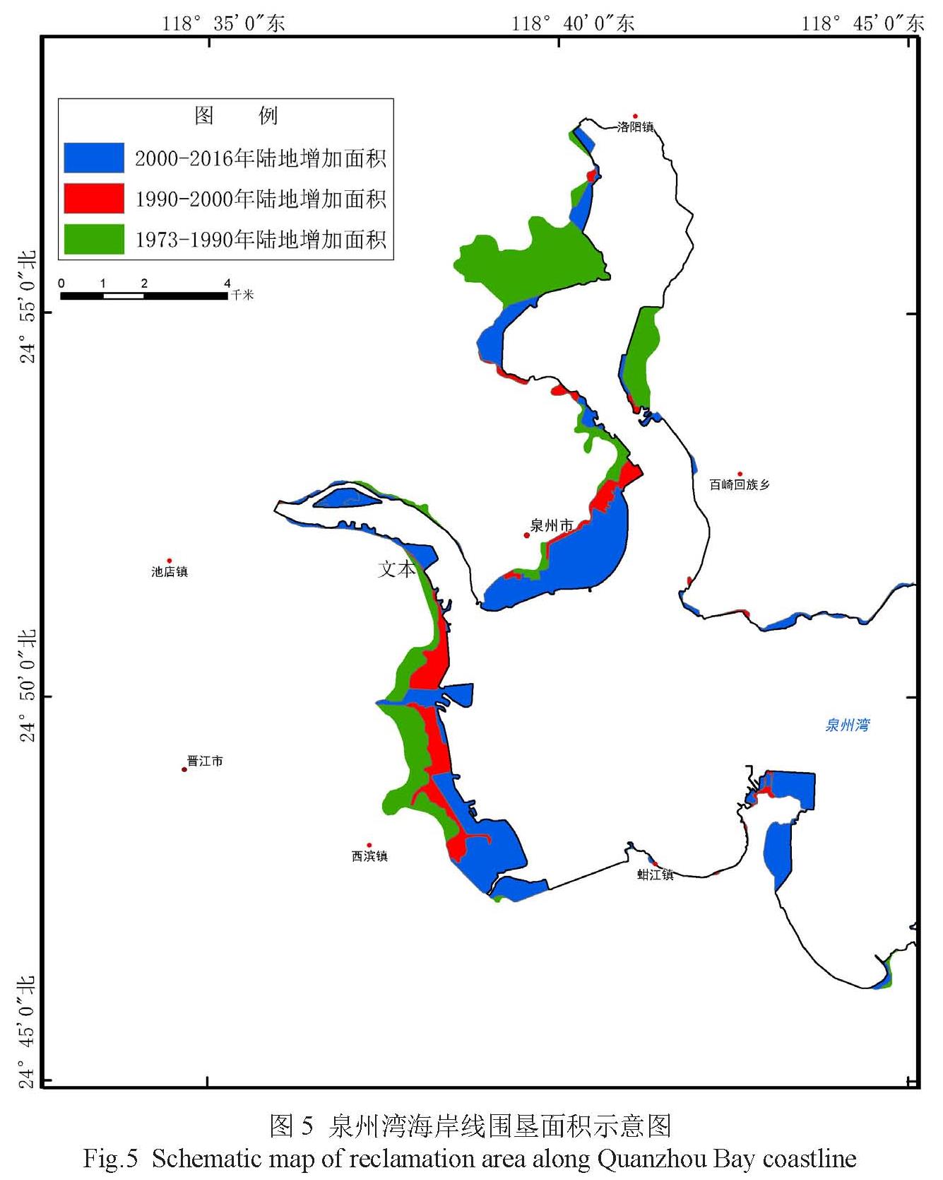
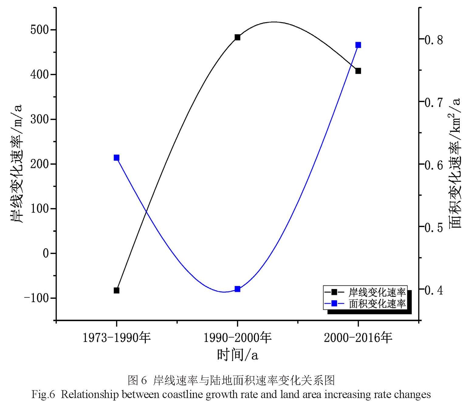
海岸线空间位置的变化导致海岸陆域面积的变化(图5)。1973年以来 ,由于填海造陆、扩建港口码头工程、围海养殖等人为因素导致泉州湾区域内大部分岸段海岸线向海扩进,造成陆域面积增加。1973—2016年,陆域进, 造成陆域面积增加。1973—2016年, 陆域面积共增加了26km2,年平均增加速率为0.6km2/a,1973—1990年、1990—2000年、2000—2016年三个时期阶段陆地面积分别增加了10.34km2、3.98 km2、12.61 km2,年平均增加速率分别为0.61km2/a、0.40km2/a、0.79km2/a。海岸线向海推进速度1990—2000年稍低于其它时相水平。
图5 泉州湾海岸线围垦面积示意图
Fig.5 Schematic map of reclamation area along Quanzhou Bay coastline
根据岸线变化速率和陆地面积变化速率关系(图6),1973—1990年岸线收缩 ,岸线增长速率为负,该时期陆地增加面积主要表现为围垦养殖和防浪堤、港口修建 ,使得弯曲度较大的岸段复杂度降低,岸线变短。在西滨镇至池店镇沿岸,围垦养殖造成陆域向海呈条带状推进,而洛阳江入海口北岸的后渚港扩建改造亦导致海岸大面积的向海扩张; 1990—2000年岸线增长速率最大,陆地面积增加速度严重滞后于岸线增长速度,该时期泉州湾区域经济发展速度较为平缓,围填海模式较为单一。向海推进区域主要为西滨镇 -陈埭镇一带以及海星街和丰海路交接一带,围垦养殖是陆地面积增加的主要原因; 2000—2016年是泉州湾经济高速发展阶段,城市建设、工业发展用地需求增大 ,各种围填海工程加快实施。该时期岸线增长速率和陆地面积增加速率契合度较高,二者速率在三个时期内均接近最大值,晋江和洛阳江入海口沿江两岸以及大多岸段都有向海推进的迹象,建成农田鱼塘、港口码头、工业园区、市政新城和沿海公路等。现泉州市政府所在地即为该时期车垵填海造地围填海工程而获取的土地,也是该时期研究区内海岸向海推进最大的区域。
图6 岸线速率与陆地面积速率变化关系图
Fig.6 Relationship between coastline growth rate and land area increasing rate changes
3.4 海岸线分形维数变化
分形维数是线性轮廓的度量,是线性体复杂性和不规则性重要的指标 ,可以较好的反映岸线形态的复杂度[37]。岸线分形维数的计算方法通常有尺码法和计盒维数法[38] ,本文采用计盒维数法计算研究区四个时相岸线的分形维数。
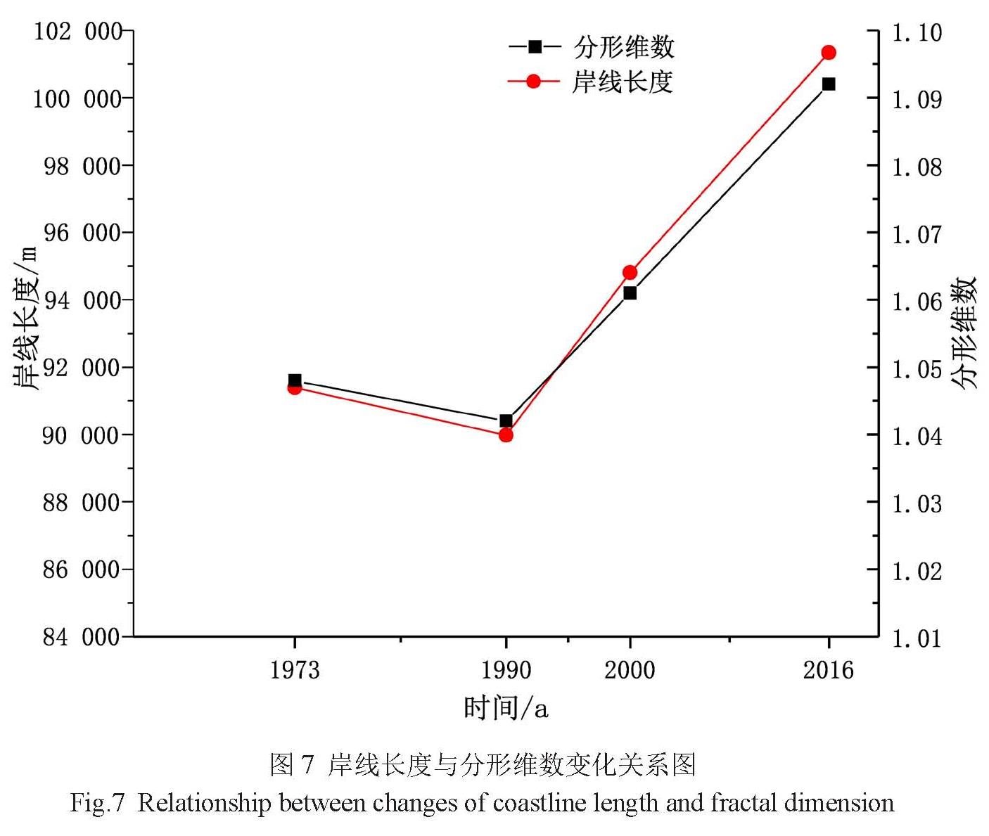
计算表明,研究区1973年、1990年、2000年和2016年岸线分形维数分别为1.048、1.042、1.061和1.092(图6)。由于研究区海岸地形复杂,岸段周边地形以山地和丘陵为主,其间多半岛、港湾,海域中岛屿星罗棋布 ,导致海岸线弯曲复杂度较高。
近40年来 ,除1990年岸线分形维数有降低外 ,其他时相的分形维数均为递增态势(图6)。其中 ,1973—1990年,分形维数减少了0.006,该时期内大量错落无序的基岩岸线修筑成整齐划一的防浪堤,用以保护沿泉州湾地区免受台风危害;从 1990年以后呈上升趋势 ,1990—2000年增加了0.019,2000—2016年增加了0.031。分形维数变化值的大小即变化强度代表了研究时期内海岸线曲折程度的变化情况 ,也反映了人类活动对该地区影响力的大小。可见 ,研究区从2000—2016年分形维数变化强度最大,与该地区海岸增长型围垦方式密切相关,海岸线向海扩进幅度最大,造成海岸线变化复杂。
结合研究区岸线类型分析,由于围垦养殖和围海造田等围填行为大多在岸线复杂度低的地段进行,故此类岸段的形状和轮廓会发生较大的改变 ,岸线复杂度会有较大提高。另外 ,研究区部分城市岸段进行的围海造陆、填海造田和修建港口码头等活动,使海岸线向海大幅推进,岸线长度增加,岸线分形维数变大。
将四个时相岸线分形维数和岸线长度叠加形成双坐标折线图(图6),分形维数变化趋势和岸线长度变化趋势基本一致,成正相关关系,除 1973年至 1990年出现下降 ,其他时相都是增加的。由此说明 ,岸线长度变化是影响岸线分形维数变化的主要因素,人类社会经济活动对岸线分形维数的改变影响较为明显。
图7 岸线长度与分形维数变化关系图
Fig.7 Relationship between changes of coastline length and fractal dimension